


This very ancient path was born long before the appearance of man. A north-south tectonic dislocation opened passes, and the most important one, located south of Villefort, provides a low-altitude passage through a 60-kilometer barrier formed by Mont Lozère and the Mas de l'Aire mountain range.
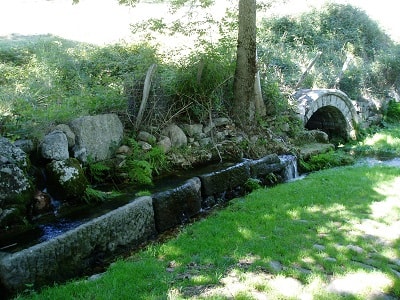
This fault generated many springs that line the route. The first animals instinctively followed it, from spring to spring, from pass to pass, in a spontaneous movement of transhumance.
Millennia later, man followed the animals by creating a drovers' track, a simple path. Some believe, not without reason, that tin convoys used it between the Phoenician ports of Saint-Valéry-en-Caux in Normandy and Saint-Gilles.
The Romans undoubtedly followed it to transport metals extracted on either side in places dedicated to the god of commerce and industry, Mercury (Mercoire, Mercoirol, Mercouly). However, it did not become a major axis until the Middle Ages. Following the division of the Carolingian Empire, which placed the Rhône valley in the Germanic Empire, the Chemin de Régordane became the easternmost route of the French Kingdom. During this time (12th-13th centuries), transport developed due to advances in harnessing: people realized that animals (like humans) pull with their weight and not their shoulders—a technique the Egyptians had already practiced during the time of Tutankhamun, fourteen centuries B.C.
The road was then traced across the high plateaus of Thort, La Molette, and La Garde-Guérin, and carved into the schist on the slopes of the Cèze valleys. In the villages, houses were built over vast warehouses that opened onto the main street through pointed arch doors, remnants of which can still be seen in Génolhac in the Gard region. Small vehicles circulated there, carrying barely more than 500 kilograms due to the materials used to construct them.
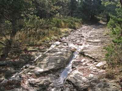
An epic poem, *Le Charroi de Nîmes*, from the second half of the 12th century, evokes this Régordane region where there were "carts and wagons in abundance" (*char et charretes i a à grant planté*, v. 950). If this was the case, it was because the climate at the time—similar to the one we know today—was highly favorable for crops. Harvests were abundant, creating wealth that needed to circulate. It was a prosperous era that could afford to build cathedrals we would be hard-pressed to even design today. Lacking suspension, the carts, with a track width of 1.40 meters, dug deep ruts into the schist through their repeated passage, much like wooden clogs eventually wearing down a stone threshold.
But the climate changed in the 14th century, becoming cold and damp. Food became scarce, and the weakened population was halved by the Black Death, while the Hundred Years' War devastated the country. Transport ceased, and the road deteriorated. The Chemin de Régordane saw only mule convoys, some loaded with silver or saffron, which were regularly robbed by English mercenaries.
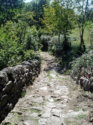
It was not until the end of the 17th century, perhaps due to the King's renewed attention to the Protestant Cévennes, that the Chemin de Régordane came back to life. The road was repeatedly modified, destroyed by runoff water, repaired, and even rebuilt. In these mountains exposed to Mediterranean weather, early autumn storms quickly washed away the gravel used to cover the road. The Côte de Bayard, between Villefort and La Garde-Guérin, had to be rebuilt every ten years. Initially, it rose straight up from the village of Bayard in tight hairpin bends, "like a ladder," according to an inspection report of the time. In the mid-18th century, this difficult path was abandoned for a completely new road hugging the slope down from Cham Morte. This is the old road still used today, now quite dilapidated, featuring remnants of paving that some call "Roman," although they were laid during the First Empire! Wagons, narrower than those of the Middle Ages and modeled after those from the Velay, rolled once again on the Régordane path, digging new ruts with a track width of 1.20 meters.
During the 19th century, the current road was built, full of curves (not long ago, 650 turns were counted between Alès and Pradelles in Haute-Loire) to soften the gradients and allow stagecoach horses to trot. Our powerful modern cars just have to adapt to it! Over time, the road's layout has shifted. There are fixed points and unavoidable passes, but between them, the route wanders here and there—like telephone wires attached to insulators but swaying in the wind.
However, this road was not just a simple trade artery. For centuries, it channeled pilgrims descending from the "North" to venerate the tomb of Saint Gilles in his Provençal abbey, south of Nîmes. Medieval literature reveals the importance of this sanctuary, designating it as the premier pilgrimage site in our country.
Saint Gilles was praised as the only saint who never failed those who invoked him with faith. Pilgrims gathered there in such numbers that 134 money changers could make a living. In Saint-Gilles, one could also embark for Rome and Jerusalem, as it was a flourishing seaport on the Petit Rhône. It was only dethroned by Aigues-Mortes after 1240, before Marseille became French in the 15th century. While Saint-Gilles was a stop on the pilgrimage route, it was primarily on the route to the Holy Land, much more so than to Santiago de Compostela; in fact, no *Jacquet* (pilgrim of St. James) is known to have lingered at the tomb of the hermit with the doe.
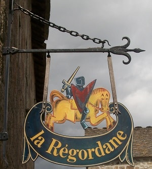
Finally, this road has a name: *Le Chemin de Régordane* (the term used in ancient documents; the improper name "Voie Régordane"—coined to sound "Roman"—only appeared in the 20th century). It takes its name from the Régordane region it crosses, just as the Chemin du Forez takes its name from the surrounding mountains. This region, or even province (*provincia de Regordana*, mentioned in a 1323 document from the Portes castle), roughly corresponded to the territory extending between Alès, Chamborigaud, Pradelles, and Largentière.
Its name, related to the words *gord* or *gourd*, which are common throughout our country, designates a land of deep valleys, perfectly matching its physical reality. Consequently, in the consulted archives, the Chemin de Régordane was only referred to by this name between Luc and Alès.
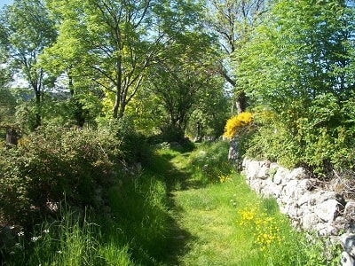
This is the history of this prestigious path, which cannot be summarized in a few lines and has been extensively studied elsewhere. Today, the road has been dormant for over a hundred years, like Sleeping Beauty (was Régordane not also a woman's name?). It is up to you to be her Prince Charming and awaken her. Follow her, paying attention to her historical remnants and the beauty of the landscapes she crosses, which transform as you lose altitude from Le Puy-en-Velay to Alès.
Watch for the first chestnut trees below La Garde-Guérin, the holm oaks as you approach the Cèze valley, the first vines in Vielvic, or the olive trees as you cross the Mas-Dieu pass, among many other wonders.
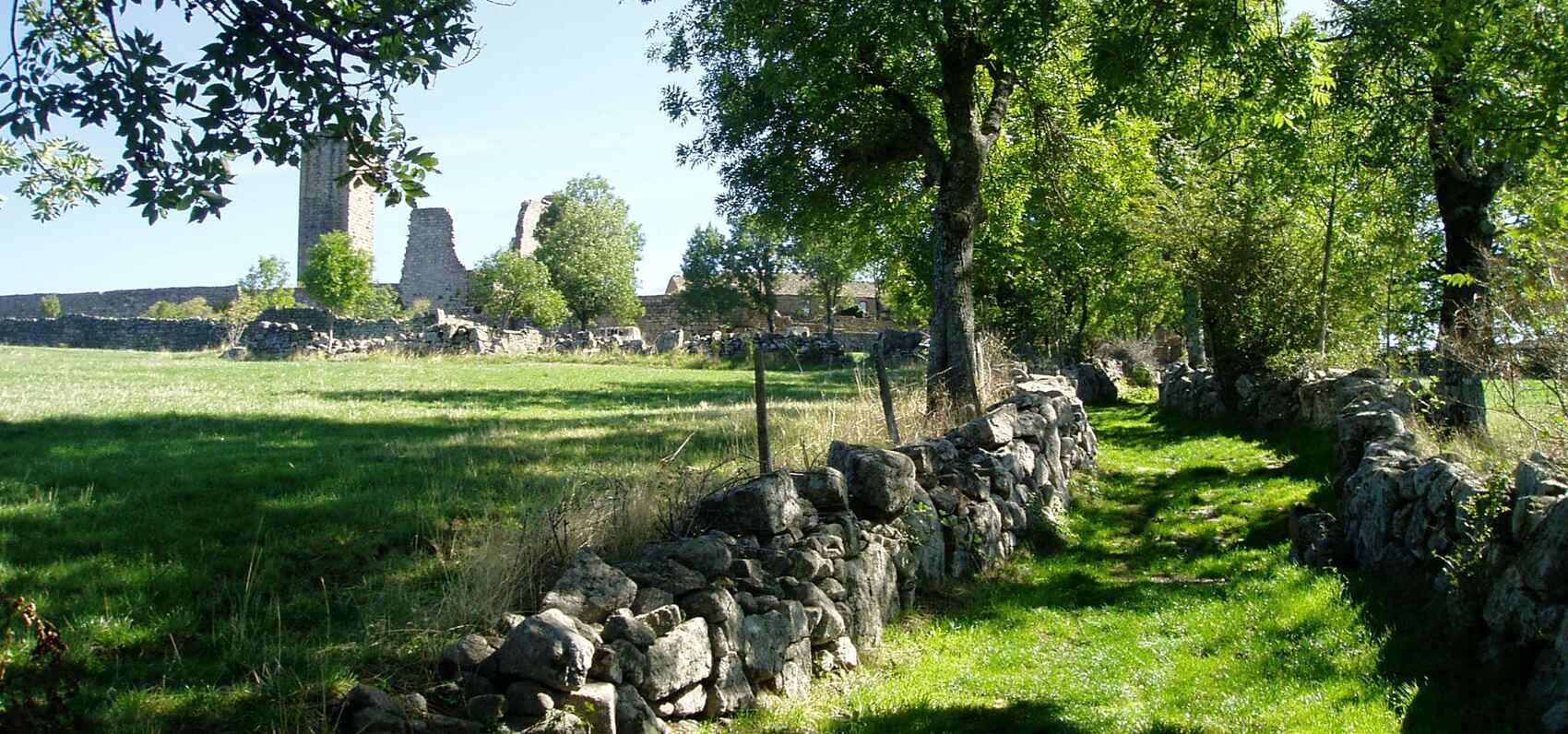
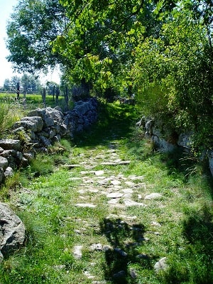
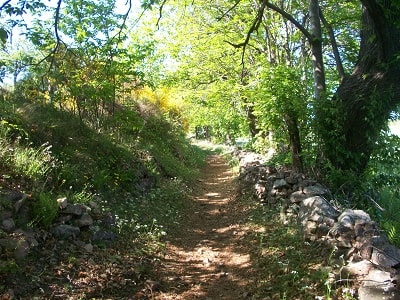
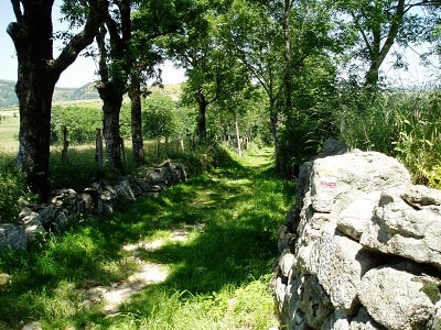
Be attentive to read its remnants: the ruts carved into the schist, the Côte de Bayard with its dry stone retaining walls that have stood for two centuries, its stone wheel guards (the ancestors of our safety barriers), and its beautiful stretches of ancient paving.
So, grab your walking stick and your backpack, and set off to discover the Chemin de Régordane. *Text prepared by Marcel Girault, July 2000. "Le Chemin de Régordane," Nîmes, Éditions Lacour, 3rd ed. 1988. History enthusiasts can also read the thesis the author dedicated to this road (Tours, 1980).*
The most remarkable section of the Chemin de Régordane is located between La Bastide-Puylaurent and Génolhac (best explored in this direction). To travel this legendary route without getting lost, you can refer to the guide written by Marcel Girault: *Le Chemin de Régordane, Guide à l'usage des pèlerins de Saint-Gilles, des Régourdiers et autres marcheurs, du Puy-en-Velay à Saint-Gilles du Gard* (Nîmes, Lacour, 1998), which provides detailed itinerary descriptions, schematic maps, and numerous notes.
The road has fallen asleep, or more accurately, dozed off... To walk it is to bring it back to life, for its primary calling was movement. It was the route of Arvernian and Greek merchants. The route of knights, pilgrims, and peddlers. Of jugglers and troubadours. A route for wine, spices, salt, oil, and cheese. But also a "strategic" route for tin towards the Mediterranean, and the path of Frankish chivalry marching against the Saracens.
The path of monks on pilgrimage to Saint-Gilles and perhaps the East. A true trail of stars in the Milky Way of travel that was the Middle Ages.
The journey of priest Aulanier du Brignon on the Voie Régordane in the 17th century.
*November 16, 1644*: Early morning departure for the journey from Nîmes in Languedoc. Dined in Pradelles, spending 16 sols. In Pranlas, a measure of oats for the mare and a light meal: 5 sols and 6 deniers. Supper and overnight stay at La Bastide: 23 sols.
*November 17*: Left La Bastide at dawn. Dined in Villefort at the Three Kings inn, spending 17 sols and 6 deniers. A snack and oats in Génolhac: 4 sols and 6 deniers. Supper and lodging at Le Pradel, at an inn named Fornier, spending 19 sols and 9 deniers.
*November 18*: Departed from Le Pradel at daybreak. Abbé Aulanier dined at La Lège in Alès, spending 23 sols and 3 deniers for himself and his mount. He had a snack and fed his horse oats at La Bitarelle, costing 9 sols and 6 deniers. Finally, he arrived for supper and lodging in Nîmes, totaling 25 sols and 9 deniers, including 2 sols for port fees.
P. Grelet de la Deyte, at the end of the 17th century, made two trips between Le Puy and Montpellier:
*"I made two trips to the city of Montpellier, one in June 1681 and the other in January 1692. To get there, you must travel from Le Puy to Cussac, Costaros, La Sauvetat, Pradelles, Langogne, Luc, Pranlas, Rogleton, the Saint-Thomas chapel, Le Thort, La Molette, La Garde-Guérin, Bayard, Villefort, Vielvic, Génolhac, Chamborigaud, Portes, Le Pradel, Mas-Dieu, Saint-Martin, the city of Alès, La Taverne (where you must cross the Gardon river), Lédignan, Crépian, and La Chapelle, to the town of Sommières, Formignargues, Pont-Neuf, and finally Montpellier. From here to Montpellier, it is about 35 leagues."*
(PAYRARD, J.B., *Petites éphémérides vellaviennes*, 1889, Le Puy-en-Velay. / "Le livre de raison de Louis Jouve" in *Bulletin historique et scientifique de l'Auvergne*, Vol. XXXIII, No. 603, 1964.)

To say that Lozère is isolated is to ignore its history, or at least to reduce it to the railway era...
Lozère, and even more so its original province of Gévaudan, was never isolated before the mid-19th century; it can even be considered a region of intense exchange. It was a crossroads rich in major routes, confluences, and pathways where kings, peddlers, monks, knights, merchants, herds, and transports constantly crossed paths. The motives for such travel were varied and intertwined: religious, economic, military, and pastoral. Above all, it was an essential and privileged contact zone between Mediterranean civilization (whether Greek, Roman, or Arab) and the Nordic world—those mysterious lands of tin and dark forests ruled by Celtic-Germanic peoples.
Among the countless roads, tracks, and drovers' paths that still traverse our province, one is perhaps particularly familiar to us: the Voie Régordane, a trail that linked Nîmes to Le Puy-en-Velay and the Arvernian country; connecting the Mediterranean to the "barbaric" world of Gaul, and even to the strange lands of Brittany and Ireland.
The origin of this path is lost in the mists of time. Likely a natural migration route and later a pastoral path in prehistoric times, it quickly grew in importance with the circulation of goods during the Roman era between the Arvernian country and the Volscian territory centered around Nemausus (Nîmes). Here, wine was traded for weapons and jewelry; oil and salt for wheat and cheese. With the advancement of wheeled transport, road maintenance and widening were organized. Tolls and "protection" fees also emerged, as the area was unsafe and the flow of wealth attracted greed—especially the oriental goods (silks, spices) arriving via the port of Saint-Gilles and heading north to the famous Champagne fairs.
Meeting places and trading posts were established, forming the beginnings of the towns and villages we know today: Génolhac, Langogne, La Bastide-Puylaurent, and Villefort. These served as stages, shelters, and warehouses for a trade that enriched the local populations. Fortresses also appeared, such as the Château de Portes or La Garde-Guérin, designed to protect (or sometimes control) these economic and cultural flows.
Naturally, the GR®700 also became a pilgrimage route. As inns, guest houses, hotels, and taverns flourished, so did places of worship and their assortments of relics, the secrets of which the Middle Ages guarded so well.
Just to the north, towards Le Puy-en-Velay, ran the Way of Saint James, as well as the Way of the Teutons, which drew pilgrims from all over northeastern Europe to the Marian sanctuary of Le Puy. This crossroads was a strategic hub for *Jacquets* (pilgrims of St. James) and other travelers who, via the Régordane, made their way down to the great monastery of Saint-Gilles and its bustling port offering numerous destinations.
As a religious, tourist, and cultural route, the Régordane was also enlivened by revelry, feasts, troubadours, and epic tales, which brightened up what could be a very long pilgrimage. The innkeepers of the time already mastered hospitality and the art of entertainment. The warrior tales of the Crusades—keeping in mind that campaigns toward the South and Spain predated the Eastern Crusades—provided rich material for dreams and legends during the long nights in the mythical valleys of the Cévennes.
You must follow the Voie Régordane to discover its ancestral pavings, whether Roman or "French." You must learn to spot, beneath the vegetation, the ruts left in the rock by heavily loaded carts carrying mysterious goods to uncertain fates. You must imagine these towns and massive archways that, at dusk, swallowed horses, mules, bundles, and peddlers, only to release them in the morning into the sunny freshness of colors, clamor, and scents...
Throughout our journey, we must learn to decipher the worries, hopes, and myths of our ancestors through the many traces they left behind. The knight William of the Short Nose (*Guillaume au Court Nez* or *Fierbrace*) is still present, and the hooves of his warhorse still echo on the ancient stone slabs. He who rode down the Régordane from Le Puy-en-Velay to recapture Nîmes from the Saracens—infidels who "believe neither in the true God nor in Lady Mary," and thus deserved an exemplary punishment:
Vestent hauberz, lacent hiaumes gemez
Ceingnent espées a ponz d'or noielez
Montent es seles des destriers atrivez ;
A lor cops pendent lor forz escus bouclez,
Et en lor poinz les espiez noielez.
De la vile issent et rengie et serré
Devant elsfont l'oriflanbe porté
Tout droit vers Nymes se sont acheminé.
A tot dis mille de François bien armez
qui de bataille estoient aprestez...
Par mijorez et par bois chevauchièrent
Par Ricordane outre s'en trespassèrent,
De si au Pui onques ne s'arestèrent...
Ten thousand knights on the Régordane? The path certainly had its hours of glory. But did too much prosperity and revelry ultimately kill it? Would a millennia-old history sink into oblivion? Like the wizard Merlin still living deep within the lake, the Régordane gently slipped into the waters of forgetfulness.
By the end of the 14th century, the Hundred Years' War made the region too dangerous, and it was abandoned in favor of Germany and Flanders. The Rhône valley and the free fairs of Lyon definitively ended its economic relevance. Revived in the 18th century by royal decree, the road withered once more, as life had moved elsewhere. Is nothing left? Just ruins, brambles, paving stones, and a path. It weaves here and there... But does it hold sirens captive in its ravines? The music, at least, remains persistent.
Scents and chiming bells tirelessly recount its countless legends. And from the uneven paving stones rises an ancient song. Enveloping and eternal are its shores. And its mirages lead nowhere but to the end of our dreams.
Chemin de Régordane or Voie Régordane?
Only the expression "Chemin de Régordane" is historically correct if we refer to the ancient forms collected since the 12th century: *itinere publico regordane, iter publicum regordane, strata publica de regordane, carreriera publica regordane, grand camy de regordane, caminus Regordane, Chemin de Régordane*.
The poet Frédéric Mistral, whose scholarship has never been questioned, calls it *camin regourdan*. Furthermore, Régordane is the name of a region, a land, or even a province, which roughly extended from Alès to Pradelles and Largentière, as we have demonstrated elsewhere (*Le Chemin de Régordane*, Éd. Lacour, Nîmes). The expression "Chemin de Régordane" is the name given to the major axis crossing this Régordane country, just as further north the "Chemin du Forez" designates the main road crossing that region, and the "Canal de Berry" applies to the waterway serving that province. Note the use of the preposition "de". The widespread term "Voie Régordane" was only adopted in the 19th century to give the route an improbable Roman origin. We have found this expression only once in the 18th century, tempered by its French translation: *via regordia, vulgarly chemin de régordane*. Moreover, this expression was only used in the context of a polemic.
*By Marcel Girault*