


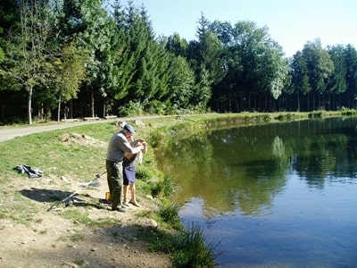
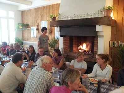
We arrive in the afternoon, some by car and others by the "Le Cévenol" train. The weather is beautiful, and the reunions are always incredibly pleasant. We settle in at the L'Étoile guesthouse, a former 1930s holiday hotel situated on the banks of the Allier River, which marks the boundary between the Ardèche and Lozère departments. Our organizers then take us for a walk through the village of La Bastide-Puylaurent and up to Lake Béal, which is specifically set up for farmed trout fishing. Their trout are also sold freshly caught using a landing net. Our fisherman-guide, Popeil, gives us a demonstration on how to bait the trout by throwing locally found red berries into the water, and it works wonderfully...
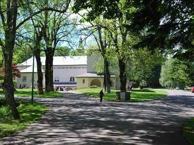
15.5 km Loop Hike. We set off towards the Notre-Dame-des-Neiges Abbey, located in the municipality of Saint-Laurent-les-Bains in Ardèche, following the GR®72 (which shares the trail with the GR®7). Founded by Cistercian Trappist monks in 1864, the abbey invites us to meditate, visit its wine cellars, and enjoy a tasting of both a dry and a sweet white wine. It is a major tourist spot for the residents of Nîmes and Alès.
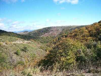
Of his stay at Notre-Dame-des-Neiges, Robert Louis Stevenson recounts: "At this late season, the residents were few. Yet, I was not alone in the public part of the monastery. It is located near the entrance and includes a small dining room on the ground floor and, upstairs, an entire corridor of cells like mine." Our deepening of meditation will take place during an appetite-building walk along the ridges of the GR®7 in search of a picnic spot offering a breathtaking view of the Borne Valley. The return to La Bastide-Puylaurent takes us through the Serres and Rogleton valleys, where we reconnect with Stevenson's historic path that runs alongside the Allier.
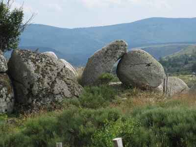
Tourism on the Watershed. We head towards the small village of Puylaurent, today merely a hamlet of La Bastide-Puylaurent, but home to a chapel of great beauty and an unbeatable view of the Goulet Mountain and Mont Lozère. Along the way, we stop at the Thort dolmen. Nicknamed the "Palet de Gargantua" (Did he follow us from Brittany to Lozère, or did he stay in Armorica and throw his puck all the way here?), this dolmen is located 200 meters from the hamlet towards Prévenchères, on the GR®72 and GR®700 trails.
Next is a visit to the Puylaurent dam, built on the Chassezac River. It is the largest dam constructed in France at the end of the 20th century. Its construction began in June 1990 and was completed in May 1996 with its filling. This colossal project mobilized 15 companies under the management of the Ardèche departmental equipment syndicate and the technical direction of EDF Hydraulic Engineering. A workforce of 200 people completed 500,000 hours of labor.
We cross Prévenchères without a glance at the famous chocolatier's shop, which has since relocated to Les Vans. However, a detour is planned to the Chassezac gorges viewpoint, situated right next to the small village of Albespeyres. The view is truly breathtaking over the canyon, Pied-de-Borne, and extending as far as the Alps in the distance.
We then head towards the medieval village of La Garde-Guérin. The itinerary includes a visit to the fortified village and a climb up its tower. The ascent is somewhat difficult, but the effort is rewarded with a very beautiful view of Mont Lozère and the Chassezac canyon. In the village streets, we witness a lovely encounter between two of our Occitan speakers and an elderly local, thrilled to converse in the traditional patois. Unfortunately, the Auberge de la Régordane, located in the center of the village, is fully booked and cannot accommodate us for a meal!
We will proceed as far as Villefort following the Saint-Gilles Way, better known as the Régordane Path. It was the ancient route of Arvernian and Greek merchants, knights, pilgrims, and peddlers. It was also the path of jugglers and troubadours, and the route for transporting wine, spices, salt, oil, and cheese. Furthermore, it served as a strategic route for the tin trade toward the Mediterranean, as well as the axis used by Frankish knights marching against the Saracens. As for us, a nap is still nowhere in sight!
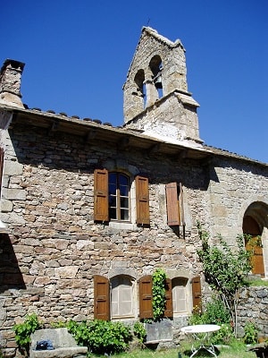
We hit the road again via the D901 toward Altier, passing the upper and lower towns. A stop at the village of Le Bleymard allows us to admire its charming little chapel, and after crossing Bagnols-les-Bains, we set our sights on Mende. We make a very brief visit to see the cathedral, its old houses, and narrow streets.
Taking the N106, we reach Rieutort-de-Randon and Châteauneuf-de-Randon. The latter, which became one of the main strongholds in Gévaudan and now features a statue of Bertrand du Guesclin, fell to the "Grandes Compagnies" (Great Companies) in 1361. One of their leaders, Séguin de Badefol, a Gascon knight, roamed the countryside at the head of 3,000 plunderers. Twenty years later, in 1380, other mercenaries seized it. These companies, half-English and half-Gascon, took advantage of the Anglo-French wars to settle in several Auvergne and Languedoc strongholds. As a saying of the time mourned the Constable's death: "Oh honor and chivalry, how much you will lose when this man passes!"
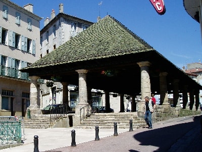
En route to Langogne, we admire the splendid grain hall (Halle au blé) built by the Saint-Géraud priory in 1742. Fourteen stone pillars support an imposing wooden framework covered with slate and Tournel stone tiles. Under this large shelter, the grain market was held, and the priory collected a "cartalage" tax for measuring the grain. We also briefly visit the Romanesque church with its beautiful 15th-century Gothic facade.
The town of Langogne particularly venerates "Our Lady of All Power" (who is not a Black Madonna). The day continues with a visit to the Calquières spinning mill. Various machines dating back to the early industrial era are displayed: they transformed raw wool into narrow strips and then threads, notably thanks to a massive machine capable of replacing the work of a hundred spinners and their distaffs.
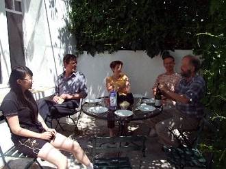
We then start our return journey to La Bastide-Puylaurent via Le Cheylard-l'Évêque. At Philippe's L'Étoile guesthouse, you immediately feel at ease: we discuss everything freely and frankly. We fully enjoy the scenery and the surrounding calm, comfortably settled under the large linden tree in the riverside park. When it is time to leave, we promise to return and relive this highly successful first experience.
Our host is a sturdy fellow who works tirelessly, notably on his websites, to promote his concept and share his motivation for a different way of living and working together. He pursues this adventure with the passion of a gold prospector: "I might be a businessman, but definitely not a mere merchant; the money will come if the idea is good and rich," he likes to say...
Thermal Cure in Saint-Laurent-les-Bains in Ardèche. To build up an appetite, there is nothing like a short circuit around and above the village of Saint-Laurent. We visit the old calling tower, which was used in medieval times to communicate and stay in touch with other hilltop villages like La Garde-Guérin or Loubaresse.
We then descend back to the village and settle at the restaurant to regain strength for our afternoon cure. The spa guests are soon dressed in their gear: swimsuit, bathrobe, cap, towel, and slippers. Off we go for ten minutes in the vaporarium! Immersed in thick fog and a stifling temperature, everyone valiantly endures. However, they do not know what awaits them around the corridor corners... The next step is a bath, but in a liquid whose consistency leaves you speechless. It is a natural mixture of a little spring water and a lot of kaolin. Imagine a pool filled with milk, thickened with an enormous amount of heavy cream, and so dense that it is impossible to stand up; you find yourself in total weightlessness. Furthermore, this liquid is extremely sticky: despite a vigorous shower and plenty of scrubbing, I retained white marks for three days! The final step is, fortunately, much more pleasant: a pool of fresh spring water. Everyone has their own space with an adjustable water jet, providing a complete massage from head to toe, front and back. If our bodies were put to the test during this half-day spa session, I can assure you that our spirits were uplifted. A memorable experience and far from dull!
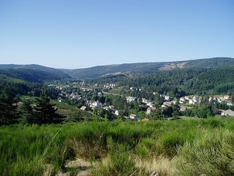
Around the large communal table at L'Étoile, our group decided to explore Haute-Ardèche on our first day. In the early morning, we leave La Bastide-Puylaurent heading towards Luc and Langogne along the Allier River, before reaching Pradelles in Haute-Loire. We make a stop at Lake Issarlès before continuing towards Le Béage.
After crossing the Bonnefoy forest, we arrive at the foot of Mont Gerbier de Jonc, right next to the sources of the Loire. Indeed, the longest river in France originates on the western slope of this conical volcanic dome, which peaks at 1,551 meters. We barely have time to admire the landscape before the group is already trekking toward the summit, as the view from up there is magnificent. Just as I catch my breath, the whole gang begins the descent. Down below, some buy jams, others mountain honey, while the rest of the group approaches the sources' monument, curiously drawn by an advertisement praising Sancerre wines irrigated by the Loire.
After an aborted picnic attempt at the Mézenc pass, we give up: the spot is far too windy for our flimsy paper plates and plastic cups. We therefore head down to the sheltered slope. Much further down, our friend Bitas finds us a magnificent clearing bordered by conifers. A ritual unpacking is done by all; tables, chairs, and provisions are brought to the site, not forgetting, of course, a little pear brandy for the thirst.
The afternoon is dedicated to climbing Mont Mézenc (1,753 m). We hike to the summits, as the mountain actually has two. Thanks to the orientation tables, it is impossible to get lost, even though the horizon is unfortunately a bit hazy. Some, lost in the clouds, swore they caught a glimpse of Mont Blanc. The Dune of Pilat, however, was obviously not visible! On the other hand, Mont Pilat (1,432 m), located between the Rhône and Loire valleys, could have been seen on a clear day.
We then set off back to the lodge, stopping at the Recoumène viaduct. This architectural masterpiece was constructed during the heroic early era of the railway by the resident engineer, Paul Séjourné. Today, there is no trace of tracks or trains. The bridge was perhaps preserved out of respect for this engineering feat (though I suspect economic reasons are more likely). Nevertheless, it has been repurposed by a bungee jumping association and thus has become a bit of a tourist attraction.
Scaling the Summits of Lozère. We hit the road again on the D6 toward Masméjean. Passing successively through Chasseradès, Mirandol, L'Estampe, and the Goulet mountain, we arrive at the small village of Le Bleymard. Food supplies are diligently gathered while a part of the group visits this village nestled at the foot of Mont Lozère, home to 434 inhabitants. This village sits at a strategic crossroads: on one hand, the road linking Mende to Villefort, following the Lot and Altier rivers; on the other, the D20 coming from Belvezet, climbing and descending the slope of Goulet, and barely crossing the village, heading towards Mont-Lozère, towards Finiels and Le Pont-de-Montvert. Via this D20, we ascend to the Bleymard ski resort, where three hotels are located.
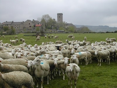
It is finally time for our snack; during our meal, we enjoy an unobstructed view of the valley and the mountains of the Cévennes. Without a nap and without rest, the group heads towards the Finiels pass. On this trail, the "draille" (transhumance path) is lined with tall standing stones, similar to menhirs, called "montjoies".
In foggy weather, these granite blocks served as landmarks for shepherds descending from the mountain with their flocks in autumn. Only a portion of our group will reach the summit of Finiels (1,699 m), due to several dropouts along the way. It is time for our efforts to cease. Further on, the bold shapes of the Mont Lozère chapel, built in 1967 by the Scouts of France, caught us by surprise. Its steeply pitched roof is designed to let snow slide to the ground without risk of accidents.
In these isolated regions, the evolution of the vegetation largely reflects the history of pastoralism and, conversely, the presence of forests. Thus, the dense beech and fir forests that populated Mont Lozère during the Gallo-Roman era were gradually destroyed by livestock. However, since the early 20th century, heather, pines, and birches have begun to reconquer neglected pastures. The ONF (National Forestry Office) also promotes the planting of beeches and firs. Today, wild boars, deer, and roe deer have once again colonized these woods.
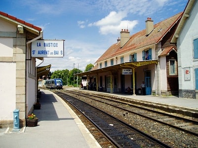
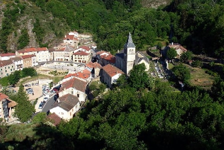
La Bastide-Puylaurent (Province of Gévaudan). In the 18th century, La Bastide-Puylaurent was just a hamlet of a few houses that lined the Régordane Path (this is how it is referred to in ancient documents; the improper designation of Voie Régordane - to sound Roman - only appears in the 20th century). It takes its name from the region of Régordane that it crosses, just as the Chemin de Forez takes its name from the surrounding mountains. This region, and even this province, "provincia de Regordana" in 1323 in a document of the Château of Portes, would roughly correspond to the territory extending between the towns of Alès, Chamborigaud, Génolhac, Villefort, La Garde-Guérin, Prévenchères, La Bastide, Luc, Langogne, Pradelles, and Largentière. There were a few inns, an active mule relay in the 17th and 18th centuries, where travelers and pilgrims found refuge and where, during heavy snowfalls, they sometimes found themselves trapped for several weeks. It was not until 1741 that a first church was built on the site where, a century later, the current building was erected.
Here the railway line coming from Mende, Allenc, Belvezet, and Chasseradès joins the one from Paris to Marseille via Clermont-Ferrand and Nîmes with the "Le Cévenol" train. Unfortunately for it, the Nîmes-Clermont-Ferrand line hardly benefits from the promotional showcase of the SNCF like the TGV trains do. Yet it offers the inhabitants of Nîmes and Montpellier, fans of peaceful hiking, the opportunity to make round trips in a day for magnificent excursions up to more than 1,000 meters in altitude.
La Bastide-Puylaurent (La Bastide St-Laurent-les-Bains), at 1,024 meters above sea level, is a stone's throw from the triple water divide of the basins of the Loire, the Rhône, and the Garonne, represented by the Allier, Chassezac, and Lot rivers, which rise on the neighboring high plateaus. At over a thousand meters in altitude, it is a good vacation spot for summer, away from the heatwave.
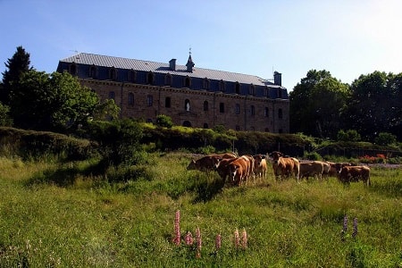
The Trappist Abbey of Notre-Dame-des-Neiges, a few kilometers to the east, attracts many visitors; some come for the peace of this Cistercian cloister, others for the enchanting setting of this peaceful valley. The Trappists have proven to be excellent winemakers, and many came here to procure quality wines, harvested in the plains of Gard and Ardèche. It was at Notre-Dame-des-Neiges that Charles de Foucauld, the famous hermit from Tamanrasset, stayed, entering the abbey as a novice in 1890 before departing permanently for the Sahara.
Robert Louis Stevenson also stopped at the abbey. "Meticulously, the day is divided between various occupations. The man who cares for the rabbits, for example, hurries from his hutch to the chapel, to the chapter house or to the refectory all day long. At any hour, he has an office to sing, a task to fulfill. From the moment he rises in the dark at two o'clock until eight o'clock when he returns to receive the comforting gift of sleep, he remains standing, absorbed by multiple and changing tasks." (Stevenson)
The thermal waters of Saint-Laurent-les-Bains have been renowned for centuries. People went there to take the waters since the 18th century, despite the difficulty of the paths (GR®72 linking Mont Lozère to the Col du Bez, passing through Villefort, Prévenchères, Thort, La Bastide-Puylaurent, and the Notre-Dame-des-Neiges abbey). The station enjoyed, in the 19th century, the era's vogue for thermal waters. The construction of the Paris-Nîmes railway and the proximity of the train stations of La Bastide-Puylaurent and Langogne allowed it to welcome spa guests from the major cities of southern France such as Marseille, Nîmes, Montpellier, Clermont-Ferrand, or Lyon. However, in the 1960s, it had to close due to a lack of clients. In 1987, the Chaîne Thermale du Soleil refurbished the entire station. At that time, it was mainly thought to treat skin diseases due to the sulfurous properties of these waters. Recent advertising for this station only mentions the treatment of rheumatism and sciatica.
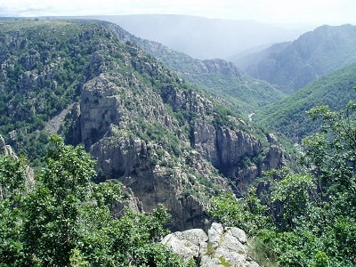
The Chassezac River, born at Moure de la Gardille, flows into the Ardèche after a course of 80 km; it waters the meadows of Belvezet, passes under the significant viaduct of Mirandol, and immediately plunges 25 to 30 meters deep into a narrow cleft between two granite walls. Then its bed widens and it falls in cascades under the hamlet of Mas, south of Chasseradès. Between Puylaurent and L'Hermet, it narrows its banks again and plunges 95 m deep. Then it flows peacefully for 5 or 6 km between green meadows, under ash trees and poplars. After following the train station of Prévenchères, it spreads into a superb lake, the lake of Rachas, where a dam holds it back.
Then the untamed river engages in its grand canyon, impossible to follow on foot after Albespeyres. But a viewpoint of the Chassezac gorges has been set up at the edge of the old D906 road which connects Alès to Langogne. In nice weather, the spectacle is truly grand: upstream, two waterfalls; then the waters wind around a massive pile of granite, infiltrate into a narrow neck, and plunge into the "Devil's Cauldron", where the rock descends sheer on both sides for 300 m. Then it flows, forming a Z, on a narrow path that it has carved into the hard rock, passing between two towers: that of La Garde-Guérin and that of Roure.
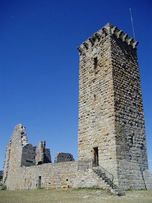
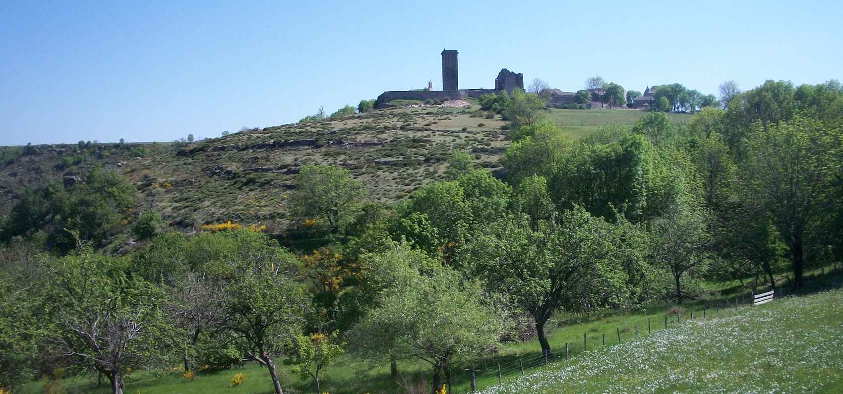
The Medieval Village of La Garde-Guérin. This beautiful watchtower, once surrounded by ramparts of which only ruins remain, stands tall over the abyss. In the "Etymological Dictionary of Place Names in France," we can read that the word Garde comes from the Germanic Wart and means guard, watchtower, fortress. Castle and village, partly restored, form a beautiful medieval ensemble of exceptional harmony. It was the domain of the "Pariers," a very original association of knights and noblemen, a police militia that protected and guided travelers on the Voie Régordane or Saint-Gilles Path.
This path became, in the Middle Ages, after the division of the Carolingian Empire (which placed the Rhône Valley in the German Empire), the most eastern commercial route of the Kingdom of France. About thirty members of the Pariers brotherhood lived permanently at La Garde-Guérin. They had meticulous and precise statutes regulating the equitable distribution of toll income and the succession of the "paréries" (co-ownership shares). Politically, they depended on the Barons (the Guérins) of Tournel.
In a text written in the 12th century, in late Latin, one can read: "castrum quod vocatur la Garda," meaning the stronghold called La Garde. It is not known exactly when the name of Guérin was added to La Garde. It is generally thought that the lords who settled at La Garde around the 12th century were Guérins, a surname common to the three great baronies of Randon, Apcher, and Tournel. At one point, these protectors deviated from their original mission: from armed escorts, they had become highwaymen and robbed those they should have protected. To put an end to these abuses, Bishop Aldebert III of Tournel made an expedition against them and besieged their lair. They submitted and returned to the right path. Their unique brotherhood lasted until the French Revolution.
The Railway Routes at La Bastide-Puylaurent. Historically, the construction of the Mende to La Bastide-Puylaurent section generated many technical problems. After initially deciding to bore a tunnel of 2,124 meters under the mountain of Goulet, work stopped after barely a third of the route was excavated. The engineers chose the current route through Allenc, Belvezet, and Chasseradès, forcing the line to a climb of 1,215 m in altitude near Belvezet. To protect this route, particularly exposed to snow, costly snow barriers had to be installed, followed by covered galleries, and it's far from a fast route! The other major line, that of the Cévennes, which connects Nîmes to Clermont-Ferrand via Alès and Langogne, is also quite hilly. Between Alès and La Bastide-Puylaurent, the track rises 897 meters over a distance of just 66 km, making it one of the three steepest gradients in Europe.