


After walking for ten years on various paths in the Cévennes—from Saint-Jean-du-Gard to the Causse Méjean via Mont Lozère—and hiking to the sources of the Loire last year, we had somewhat overlooked the entire region located between La Bastide-Puylaurent, Valgorge, Les Vans, and Génolhac. This area corresponds exactly to the route of the GRP Le Cévenol. We therefore decided to fill this gap by booking accommodations along the entire trail.
We arrive at La Bastide-Puylaurent (1,024 m) at 5 PM. Philippe Papadimitriou warmly welcomes us at L'Étoile Guest House. The meal is hearty—exactly what ambitious hikers need for the road ahead!
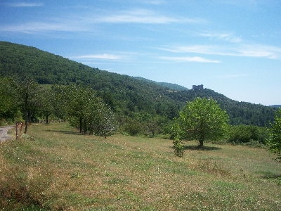
We depart at 8 AM. The weather is a bit uncertain, but the rain holds off for now. We follow a quiet forest path and then a country lane with little elevation gain until we reach the Abbey of Notre-Dame-des-Neiges (1,081 m). We spot a few men, likely monks, bustling around the farm. The abbey is undeniably magnificent in its lush green setting.
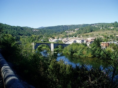
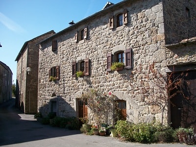
We reach Saint-Laurent-les-Bains (820 m) from above. The village only reveals itself 500 meters before arrival, deeply nestled at the bottom of a valley between two imposing mountains that seem to crush it with their mass. It is a charming village where old stone houses and more recent buildings, such as the thermal baths, blend together harmoniously.
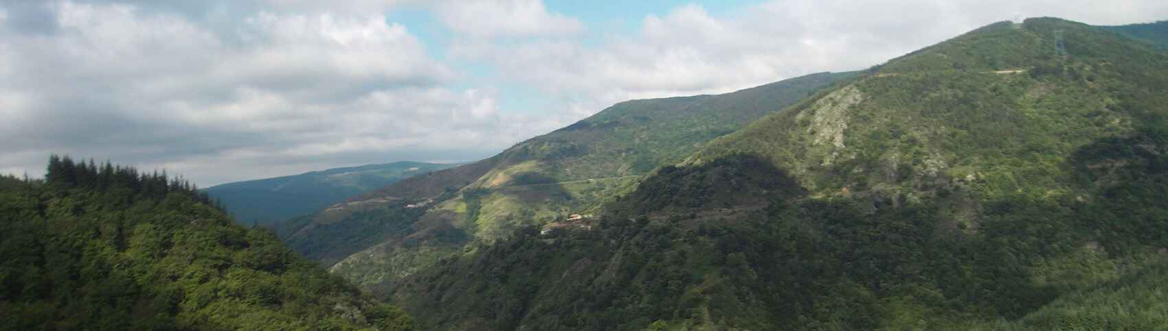
Just a kilometer past Saint-Laurent, we experience our first route uncertainties due to a fallen sign and a severe lack of markings, likely caused by recent path widening for logging machinery. However, the small pass we eventually reach offers a breathtaking panorama of wild massifs and incredibly steep slopes.
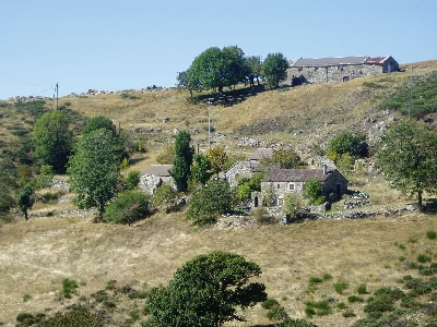
We then begin our descent toward Conches (800 m), a ruined ancient hamlet that once proudly housed several families. About 300 meters further on, we discover an isolated old farmhouse without any road access, yet undergoing an impressive renovation! It can only be reached via a rugged mule track. Building materials are transported via a spectacular zip line stretched high across the neighboring valley, following a long, jarring journey by 4x4 and then by wheelbarrow... What a massive undertaking! But the location is absolutely stunning!
The valley below the zip line is watered by a crystal-clear stream that practically begs you to swim: right under the old bridge lies a large, deep natural pool. We would have loved to dive in, but with heavy rain threatening, we continue on our way. Shortly after, we cross paths with four lovely, vibrant Belgian hikers in their fifties, full of smiles.
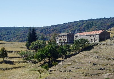
We arrive at Le Mas de Truc, a beautifully renovated old village where one house features a picturesque "storm bell tower" complete with its magnificent bell. Heading toward the Col de Toutes Aures (1,199 m), the trail becomes less distinct and is occasionally overgrown with vegetation, forcing us to cut across the open meadows.
Loubaresse (1,230 m) is a high-perched village where you can find all the essentials: a café, a restaurant, guest rooms, and a table d'hôtes. The small grocery store and its owner are incredibly charming. Around 1 PM, we eat lunch perfectly sheltered from the biting wind in the bright sun, right in the church's entrance porch. Leaving Loubaresse, we catch a fleeting glimpse of Valgorge far down in the valley. Unfortunately, upon reaching a forestry (DFCI) road, we completely miss our GR turnoff and mistakenly embark on the GRP Tour du Tanargue! We only reconnect with the Cévenol trail 5 km later on the Sapet crest—where we weren't supposed to pass until tomorrow! We decide to take the long descent toward Valgorge, a route we will have to repeat in the opposite direction the next day. Though extended, the stage remains undeniably beautiful.
Valgorge (570 m) is a beautiful, historic village. We stay at the communal gîte where absolute trust reigns: the manager simply left the door wide open, with the key resting quietly on the table! We had reserved dinner at the local restaurant, 'Le Tanargue'. We are a bit surprised by the elegant, formal welcome from the owner and waiters, all dressed in ties, while we stand there in our hiking shorts and flip-flops. Fortunately, everything goes extremely well; the meal is excellent, refined, and very reasonably priced.
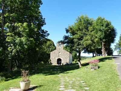
We depart Valgorge at 9 AM, hoping for a significantly shorter stage than yesterday's. We re-ascend the steep slope we mistakenly descended the day prior. Feeling rested, it genuinely seems less difficult than feared, though the continuous climb still takes nearly two hours. Reaching the crest at 1,010 meters, the panorama is breathtaking. Down below to the right, we can see the village of Dompnac, and straight ahead is the Chapel of Saint-Régis (700 m), which we will reach in about an hour. At the quiet chapel, we stop for a regenerating snack and spot a sporty couple of Luxembourgish hikers setting out on the Sentier des Lauzes, which our GR also follows for a few kilometers. We will undoubtedly run into them again...
Ready to set off again, we notice a lively group of local volunteer hikers in their sixties also taking the Lauzes trail. To accommodate the less athletic members of their group, they decide to cut directly via the forestry road to reach Saint-Mélany. This unfortunately misleads us, especially since a couple from the Pyrenees, quietly picnicking at the Croix de Grimal, unknowingly blocked our GR's turnoff marker. We blindly walk almost 500 meters before realizing our clear mistake. We immediately turn back, to the dismay of the apologetic Pyrenean couple! However, we do not regret the detour; the Sentier des Lauzes is absolutely superb. It features ancient chestnut groves, traditional cobbled paths (calades), fine dry-stone walls, terraced vineyards, and old farms. We pass incredibly close to the private houses, almost walking through the residents' yards, yet they accept our brief intrusions with warm smiles. The winding trail is also regularly adorned with highly original stone and wood artworks that seamlessly integrate into the rocky landscape.
At Le Travers (600 m), right near the gîte, we head straight instead of taking a small, hidden path to the left. Arriving on a road, we bump into the Luxembourgish couple again. Surprisingly, even though they hiked this exact route last year, they are also lost! The gentleman is determined to find the trail and strongly motivates us to retrace our steps despite the crushing heat. We finally get back on the right path, wandering through a magnificent valley. In a very shady spot near a cool stream, we gladly stop for a picnic.
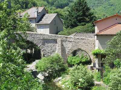
Upon arriving in Saint-Mélany (465 m), we are highly surprised to find our Luxembourgish hiking friends comfortably seated on the terrace of a 'Café de Pays', which also serves as a small restaurant and local grocery store. Since the waitress is incredibly charming, we gladly stop for a cold lemonade with them. At the historic Brousse bridge, we cannot resist the strong call of the water. The natural pool stretching beautifully under the old arches is extremely tempting: the water is lively, crystal clear, and quite deep. The smooth rocks bordering it allow bathers to dry off in the hot sun and provide a perfect spot for children to jump and dive. An absolute treat! We emerge feeling refreshed and light on our feet, ready to tackle the long 5 km cobbled ascent to the Croix de Fer pass via a rugged old mule path. It is very hot, but fortunately, the path is beautifully shaded and absolutely stunning.
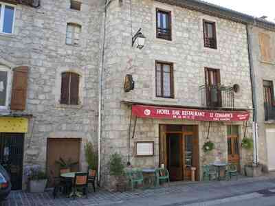
At the Col de la Croix de Fer (818 m), we take the small road to reach Auberge de La Peyre (860 m), which also offers cozy guest rooms. The welcome is friendly, and the meal, though simple, is very good. The local products are of excellent quality: delicious homemade charcuterie, a fabulous porcini mushroom omelet prepared by the owner, and a succulent apricot tart baked by his mother.
We start our third stage around 9 AM in already warm weather. The trail down to Dépoudent (650 m) is highly shady and wildly beautiful. It's an old traditional mule path exactly as we like them, even if natural erosion and local wild boars do their best to destroy it over time. Dépoudent is a very pretty, isolated hamlet with only a few farms; it has remained perfectly authentic, and you can still easily feel the spirit of the old hardworking Cévenol farmers.
In Saint-Jean-de-Pourcharesse (600 m), we openly admire the beautiful open bell tower—a classic 'clocher-peigne'—and some lovely ancient houses before slowly descending into a vast, old chestnut grove. At Les Aliziés, we are incredibly fortunate to meet the very last farmer of the hamlet. He kindly directs us to a very cool fountain to fill our water bottles, while he uses the basin to naturally cool his beers and fruit juices for lunch. Another friendly villager warmly invites us to visit his spacious, renovated home: large beautifully tiled rooms, wide stone archways resembling a manor, and finally, a stunning covered terrace overlooking the valley, where he offers us a cold drink. We deeply appreciate the interlude, but time is ticking, and we must move on. We picnic on an old shady bridge, just before a fast group of mountain bikers speeds down the steep slope, appearing completely without warning—a truly impressive sight!
At Champmajour (240 m), we go down to specifically see the village fountain: a beautiful, quiet spot with its heavy stone vault tucked under a green terraced garden. Next is Chambonas (160 m), though with too much road and far too many fast cars! The narrow passage over the bridge towards Les Vans is actually quite amusing, however: it is very long, single-lane, and features two or three small stone refuges allowing pedestrians to escape the risk of collision with a vehicle. You have to carefully calculate your crossing based on the speed of the approaching cars and your own pace between two refuges!
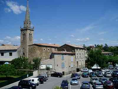
Les Vans (179 m) is a bustling, popular tourist town. The streets of the historic center are very pretty, but packed with people! Many restaurants are already completely full by 6 PM. We finally find a table at 'La Feuille de Chou', a charming place slightly away from the old town. The food is very good, and the prices are quite reasonable. We sleep peacefully at the Hôtel des Oliviers, where the staff gives us a very warm welcome. Unfortunately, right in the middle of the night, around 2 AM, a group of young people smoking in their room triggers the general fire alarm. After five long minutes of a piercing siren and a memorable scolding from the manager, they think they are being extremely clever by smoking again, this time by the open window. A sudden draft blows the smoke directly back into the room, and the loud alarm goes off again! They very nearly spent the rest of the night under the stars.
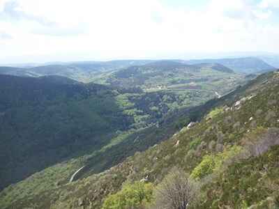
We depart at 9 AM. Since there was a heavy thunderstorm during the night, there is thick morning mist slowly rising from the warm ground. The slope to access the ancient village of Naves is very steep but climbs via a pristine, well-preserved cobbled path (calade). The houses are magnificent, sometimes connected directly by suspended stairs forming stone arches that are highly pleasant to stroll beneath. We then take a steep, rocky path, functioning like a balcony high above the Bourdaric valley, whose immense beauty can only be guessed at through the thick mist!
We cross a lovely, dense chestnut grove before arriving at Alauzas (490 m). We then follow a fairly easy forestry (DFCI) path to reach Brahic (508 m). And there, disaster strikes: the GRP markers completely disappear! Fortunately, our topo-guide indicates that a small hiking path, simply marked in yellow, heads essentially in the right direction. How far? We'll see, but it’s already a very good help. From time to time, we spot a surviving yellow and red marker. At Murjas, even the wooden direction signs have been severely cut off to completely remove the GRP markers! We descend deeply toward the torrent via an incredibly steep and badly damaged old cobbled path. Given the highly humid weather, it’s quite slippery and dangerous. The location is incredibly beautiful—we could have easily swum there if the air hadn't been so cool. This is followed by an exhausting, endless climb on a steep slope through an old chestnut grove, this time bathed in bright sunshine. The ambient temperature suddenly spikes by at least ten degrees!
We picnic near Malbosquet (430 m). The unexpected storm heavily surprises us there; we quickly put on our rain capes and set off for another very long ascent right in an old chestnut grove. We finally find our lost GRP a little after Les Escoussous, near Malbosc. The high ridge path (660 m) in the forest seems very long to us; there are very few sweeping viewpoints! The steady ascent drags on. Just 1 km from the Col de Péras, we truly think we will find the GR®44A, which descends directly towards the Château du Cheylard and would bring us much closer to our evening gîte. Unfortunately, after 500 meters, the trail gets totally lost in the dense forest... we inevitably turn back! The dark storm thunders heavily again; it approaches rapidly, and we pull our rain capes back out.
At the Col de Péras (771 m), the GR seems to be in very poor condition; there are many loose stones made incredibly slippery by the rain, so we wisely decide to safely descend via the main road towards Aujac (520 m).
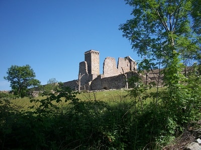
A little before the village, we head towards the Château du Cheylard to descend deeply to Aujaguet, and finally to La Baraque (330 m). We reach our welcoming gîte around 7 PM. The welcome is incredibly warm; Lise-Anne, the Quebec partner of Jonas Nivon, our host, graciously shows us our rooms. Everything is highly charming and well thought out; it’s truly a beautiful eco-gîte. Genuinely concerned about our fatigue, she kindly offers us herbal tea, chats freely, and laughs a lot, immediately establishing a strong, friendly connection. La Baraque boasts a large organic vegetable garden and a small farm that generously supply much of the wholesome food for our dinner. Everything is absolutely delicious, with special praise for the chocolate, almond, hazelnut, and caramel tart. This pure delight makes us easily forget the day's deep fatigue, and we happily enjoy lingering at the table over one last piece of tart with one last herbal tea.
We slowly leave La Baraque around 10 AM, as today's stage to the high gîte of Tourevès—perched on the slopes of Mont Lozère, near Génolhac—is not very long. We smoothly take the path we successfully ended on yesterday; it seems much more beautiful without the crushing fatigue of the previous evening.
We quickly reach Aujac (520 m) and confidently descend towards the Souillas bridge, a truly beautiful spot for swimming that was highly recommended to us. Under a bright sun, we quickly decide to stay there for a while to enjoy a swim and happily eat our picnic. We set off again at exactly 1:30 PM on a steep, challenging climb towards Charnavas-le-Haut (480 m).
We only see this beautiful village from a distance, as we turn sharply at the very first house towards a green pass before deeply descending into a quiet valley. There, we find the absolute smallest bridge of our entire journey; it has absolutely everything a large bridge has (stone arch, heavy parapets...), but completely in miniature.
Upon our highly anticipated arrival in Génolhac (540 m), the air is very heavy. We stop at a cafe to simply drink a cold lemonade, and then actively discuss with the Tourist Office about the severe marking issues and lack of maintenance on the GRP "Le Cévenol". We linger a bit because it’s genuinely nice to be walking in the old alleys. We finally start the long ascent towards the high gîte after 4 PM via the old historic Génolhac-Villefort road.
The sudden storm surprises us directly at the foot of the slope; it rains heavily during the entire three-kilometer ascent to the Col de Bergeronnette, exactly 500 m from Tourevès (800 m), a truly magnificent balcony hovering perfectly over the deep Génolhac valley. Just when we arrive, a beautiful ray of sunshine forcefully pierces the dark clouds and magically creates a highly bright rainbow directly above the town; it’s absolutely splendid!
The warm evening meal begins with an excellent homemade 'cartagène' aperitif, beautifully accompanied by delicious herb olives. The rustic meat pâté from the nearby Chamborigaud butcher is an absolute treat. The dinner is even more enjoyable as we happily share it with a lovely family of highly enthusiastic Parisian hikers.
We depart from Tourevès precisely at 9 AM to comfortably arrive in Villefort before the expected heavy storm around 1 PM. The beautiful forest path, neatly terraced high above the valley, sometimes beautifully reveals sweeping panoramas. We can even clearly see the distant Mont Ventoux, which Jacques Lemaire, our excellent host in Tourevès, had already proudly pointed out to us in the early morning mist. Exactly at the Col du Marquet, there is a highly scenic viewpoint as we pass closely behind the incredibly large rock that lines the road.
At the quiet Col de Rabusat (1,099 m), we happily stop for a small, well-deserved snack. A dynamic young couple comes walking from the direction of Mas de la Barque right on Mont Lozère; they have successfully picked fresh chanterelles along the way and excitedly plan to perfectly cook them for lunch. They leave just ahead of us. We then faithfully follow a beautiful ridge line through thick gorse with a tiny bit of rock climbing to perfectly spice up the route. On the rocky descent, we surprisingly find their lost bag of mushrooms right on the green grass of the path. Knowing they are definitely not very far, I run quickly to faithfully return it to them. Shortly after, we meet a lovely German hiker who is very soon seventy years old, yet still incredibly alert and deeply enthusiastic; she kindly offers her camera for a nice photo of her with Villefort majestically in the background, very far away in the deep valley.
Then we securely take a very long path that easily leads us directly to Villefort (591 m). It is exactly 12:40 PM; it slowly starts to rain, and we wisely decide to comfortably eat indoors at the very first nice restaurant that presents itself: "La Brindille". The hot daily menu is very good and truly not too expensive. We deeply appreciate our choice to eat warmly indoors as the cold rain heavily intensifies outside. Our picnic safely stays in our bags; it will definitely still be highly good tomorrow! When we finally go out around 2 PM, it is absolutely still raining.
We stop at the local press house to simply buy some interesting reading material and nice postcards to keep us pleasantly occupied at the Hôtel du Lac (615 m). At 5 PM, the warm sun finally manages to break brightly through the heavy clouds; we take a very calm walk smoothly along the lake. It is nice, but we are genuinely not really into it, as we are already heavily thinking about our crucial stage for tomorrow. In the warm evening, exactly at dinner, we thoroughly enjoy the Bleu d'Auvergne flan as a delicious starter, followed by tender Lozère veal, and the "homemade" wild blueberry tart perfectly paired with sweet chestnut fondant and fresh raspberry coulis. The local staff are incredibly charming.
We completely leave the cozy hotel a little before 9 AM; it is nicely cool, the absolutely perfect temperature to properly begin the long ascent towards La Garde-Guérin strictly on the GR®700, the famous Voie Régordane. The old stone calade is, at several times, still in very good, workable condition. You can definitely see that we are extremely close to Mont Lozère because the heavy stones are remarkably round and quite large; it is solid granite, highly unlike the flat calades exactly at the beginning of our long tour, where the dark stones were clearly schistose, very flat, and thin, meticulously placed vertically tightly against each other. The path rises extremely well; we possess a truly beautiful, commanding view over the large lake directly onto Mont Lozère. We can highly clearly see the exact path we quickly descended yesterday right after the Col de Rabusat.
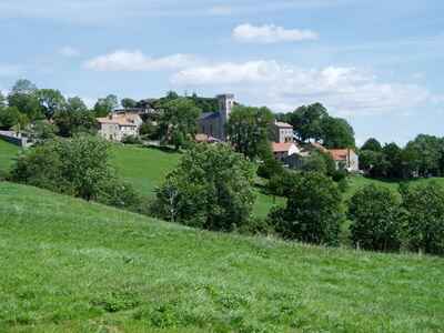
We very soon arrive at a wide plateau where we clearly see La Garde-Guérin (874 m). It is not yet ten o'clock; we take the good time for a quiet visit to this perfectly preserved medieval village (12th-15th century). I bravely climb to the very top of the tower; it’s quite heavily athletic: you access the high summit strictly through a very narrow stone tunnel about 90 cm wide and only 2 meters high, absolutely no stairs, just holes securely in the wall and a single metal bar to physically hoist yourself securely onto the platform at the very top. The resulting panorama is absolutely superb: the deep gorges of the Chassezac widely to the east, and Mont Lozère to the vast west. We leave the historic village by a very pretty, shady path, quietly passing in front of an ancient wash fountain and safely reaching a prominent belvedere, once again majestically overlooking the dizzying gorges of the Chassezac.
We then happily follow a pristine golf course, and the path winds beautifully through the green meadows before comfortably arriving at Albespeyres (870 m). We are heavily more focused on admiring the very old, rustic farms and the incredibly large, beautiful vegetable gardens than strictly on the GR markers; we stupidly miss the sharp descent to the Chassezac, normally passing right under the railway. We continue blindly on the road and ultimately catch up with the GR just before Prévenchères by effectively crossing the huge dam that heavily holds back the deep waters of the Chassezac. We meet an incredibly old, wise hiker actually living deeply in Albespeyres; we openly tell him about our small mishap, and he clearly explains that we definitely couldn’t see the crucial turn-off markers for the GR because there was a white car heavily parked exactly in front! That instantly reminds us of something very similar... the happy hikers quietly picnicking completely near a cross.
Past La Molette (1,006 m), we steadily gain high altitude again (1,133 m) while quietly following vast, sweeping meadows where peaceful cows graze freely. After Le Thort, we take a quiet, dark path smoothly alongside a nice mushroom wood, then we securely arrive at a very old heavily tarred road, half-eaten by the encroaching green vegetation, now exclusively reserved for hikers. Carried away by our momentum, we once again totally miss a crucial turnoff to the direct left to safely reach La Bastide-Puylaurent simply via a highly scenic small secondary road...
Upon our highly anticipated arrival at L'Étoile, safely at La Bastide-Puylaurent (1,024 m), Philippe Papadimitriou generously offers us hot tea; all is remarkably well that definitely ends extremely well!
This specific hike is most certainly one of the absolutely most beautiful we have ever bravely done, walking highly from crest to crest, passing through deeply enclosed, quiet valleys, crossing fast, pristine streams where we happily enjoyed swimming, generously offering us truly breathtaking, majestic panoramas flawlessly carved from deep schist and solid granite... And how can one not marvel at this incredibly magnificent ancient architecture that clings desperately to the steep slopes, somewhat completely tamed by endless kilometers of incredibly sturdy terraces built strictly by hand, firmly stone by stone. What an incredibly beautiful, striking country! Eric Dubois