Aubrac between Lozere, Aveyron and Cantal |
 L'Aubrac is a volcanic massif that extends approximately 40 km in length and between 4 and 18 km in width, covering an area of 450 km² along a Northwest - Southeast axis. It is one of the most typical mid-mountains of the Central Massif, with characteristics that are both rugged and fascinating. Its highest point, the Signal de Mailhebiau, reaches an altitude of 1,469 meters.
This impressive massif is composed of a superposition of basaltic flows resting on an asymmetric crystalline base. On the Southwest side, steep slopes allow for a quick transition from the summit of Aubrac to the Lot valley within a few kilometers. Numerous torrents, called Boraldes, cut deeply into this slope. For example, the Boralde of Saint-Chely-d'Aubrac originates at an altitude of about 1,340 meters and descends to only 800 meters in the village of Saint-Chely, located 8.5 km from the summits.
On the opposite side, the eastern slope is characterized by a vast plateau with heavy and monotonous shapes, where the bumpy topography seamlessly blends into the lower plateaus of Margeride, in the region of Aumont-Aubrac and Saint-Chely-d'Apcher.
 The basaltic flows of Aubrac are the result of fissure volcanism. Between these flows, layers of pyroclastic formations are abundant. These materials, primarily cineritic, constitute about half of the volume of the edifice. Rather than forming a series of individual structures, they regularly alternate with the basalts. These pyroclastic formations, often a brilliant red, are visible along the summit roads and in the few cuts of the landscape. Once interpreted as elements of paleosols indicating warm climates, these red levels actually result from cooking phenomena related to the arrival of high-temperature flows.
Until recently, it was believed that the volcanism of Aubrac dated back to the Villafranchian. However, recent research indicates that it dates back to a much earlier period, between 8 and 7.5 million years ago, with some later manifestations around 5.8 million years ago. This volcanism developed along hercynian fractures already present in the bedrock.
To properly understand Aubrac, one must also consider its basement edges. To the North-Northeast, granite dominates, while metamorphic material is observed to the South and Southwest, where the landscape is more rugged, cut by the Boraldes. The granite from the North-Northeast is part of the southwestern end of the Margeride massif; it is distinguished by its porphyritic texture, accompanied in some places, such as Saint-Remy-de-Chaudesaignes and north of Laguiole, by a two-mica granite with finer grains.
 During the Quaternary, the volcanic plateaus of Aubrac were covered by ice, forming a small ice cap. These glaciers extended over the highlands, flowing in short tongues along the main valleys. The valleys on the Southern slope retain few traces from this time, due to erosion caused by melting waters, whereas in the Northeast, the remains are better preserved. The glacial cap, relatively thin, measured between 150 and 250 meters in thickness, which mitigated its erosive power. Positioned on gently sloping terrain, the glaciers moved slowly; only the tongues of ice left more marked traces on the glacially polished rocks, such as those observed in the region of Pont-de-Gournier, north of Nasbinals.
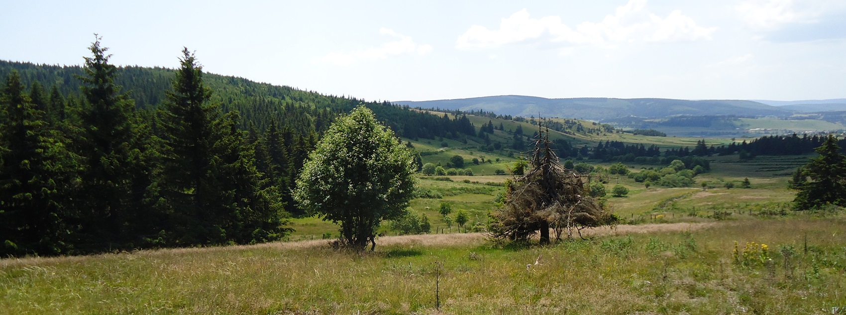
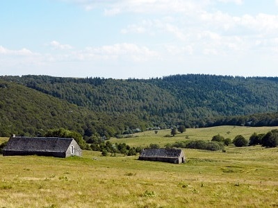
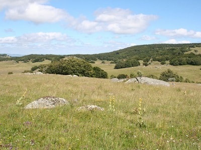
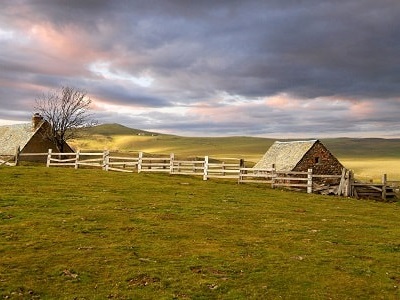
The plateaus of Aubrac, battered by winds, are almost devoid of trees. In this mountainous region of Auvergne, forest is rare, mainly found between the villages of Aubrac, Saint-Urcize, and Laguiole, as well as on the Southwest slope of the massif. Everywhere else, the plateau, which gently rises above 1,400 meters in altitude, is covered with a uniform layer of grass. The monotonous horizons of Aubrac are rhythmically interrupted by stone walls that delineate vast parcels, winding along the mountainside and framing sunken paths that lead into the countryside. The farms, which are rare, are often isolated or grouped into small hamlets, particularly in the northern part. Low and compact, they seek refuge from the burle wind that blows across the plateau. In the higher elevations, around the triangle of Marchastel, Aubrac, and Saint-Urcize, one can still see many often-abandoned burons.
 The overall impression is one of isolation: few inhabitants, no cities, only a wild nature that imposes difficult living conditions. Winter is long and harsh, and snow is abundant, as reminded by the long poles planted in the ground along the paths, while a sign warns travelers to exercise caution on the Nasbinals-Aubrac road in case of a storm.
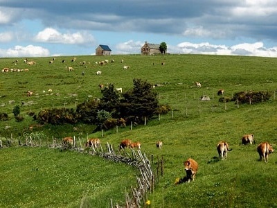
Aubrac, with its unique landscapes, is divided between three departments (Cantal, Lozere, and Aveyron) and three different regions. Isolated and rugged, this high plateau is also a borderland. The landscape, dotted with meadows and vast pastures, as well as rustic farms housing livestock buildings, testifies to an agricultural economy based on livestock and pastoral life. Like Cantal, Aubrac has long practiced cattle farming for milk production, which is used to make the traditional buron cheese, "Laguiole", similar to Cantal cheese. This farming relies on the Aubrac breed, which has a light coat and is known for its hardiness, just like the Salers breed, which provides milk, meat, and labor. The grazing areas often belong to large landowners, to whom small farmers entrust their animals for summer grazing.
This dynamic has led to the accommodation of transhumant herds coming from Languedoc during the summer. The low hay production has resulted in cattle sales, thus promoting the growth of markets in the small mountain centers. The configuration of the plateaus, with sub-equal altitudes and the absence of deep valleys like those in Cantal, explains why there is no dual layer of vegetation here: bottom meadows for winter hay and summer pastures. Aubrac is comparable to Cezallier or the plateau between Meygal and Mezenc. While hay meadows are becoming scarce, the pastures remain vast. In the Lozerien Aubrac, meadows occupy barely 30% of the utilized agricultural area (SAU), while pastures account for nearly 69%, leaving only 1% for some crops, mainly potatoes.
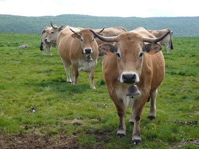 The livestock system in Aubrac is complex: it produces milk and cheese, but, like in Cantal, the sale of calves is also common. Small farms and even larger operations have faced massive abandonment. The depopulation has been severe, with many inhabitants of Aubrac having migrated to Paris. This demographic decline explains the currently low densities and this feeling of vastness and solitude, with few traces of human activity. However, the inhabitants of Aubrac have shown resilience, seeking to improve the productivity of their herds. For a long time, they have practiced crossing the local breed with the Charolaise breed to obtain both milk and well-conformed animals for meat. This choice has, however, endangered the pure strain of the Aubrac breed, which is now regaining interest, considered more adapted and less fragile than the others.
 Laguiole cheese, weighing between 40 and 50 kg, was originally produced on farms in the burons. However, its production has declined due to rural exodus and labor shortages, falling from 600 tons in 1928 to only 25 tons in 1958. Since then, Laguiole has obtained a controlled designation of origin, redefined in 1976 (cheese produced between May 25 and October 30 using milk from pastures located over 800 meters, and aged for 120 days). The designation area covers 24 municipalities. Today, this cheese is mainly produced in dairies, led by a cooperative founded in the West of Aubrac, whose production continues to increase. Efforts are also being made to revive the production of buron cheese near Saint-Urcize, seeking new markets for this typical and local product.
Finally, alongside the intensification of dairy production and the organization of producers, meat farming has developed within relatively large operations. Young animals are delivered to the market after one or more grazing seasons, marking a shift towards an extensive type of farming that requires less labor and takes advantage of the vast available land. In the municipalities of Lozerien Aubrac, meat production is becoming almost exclusive, unlike in the West, where nearly half of the farms exceed 50 hectares. Beyond agriculture, the small centers of Aubrac, such as Nasbinals, Saint-Urcize, and Laguiole, are increasingly turning towards tourism.
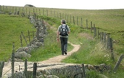
Former holiday hotel with a garden along the Allier, L'Etoile Guest House is located in La Bastide-Puylaurent between Lozere, Ardeche, and the Cevennes in the mountains of Southern France. At the crossroads of GR®7, GR®70 Stevenson Path, GR®72, GR®700 Regordane Way, GR®470 Allier River springs and gorges, GRP® Cevenol, Ardechoise Mountains, Margeride. Numerous loop trails for hiking and one-day biking excursions. Ideal for a relaxing and hiking getaway.
Copyright©etoile.fr