|
Lillooet Far West of the Pioneers
|
     
|

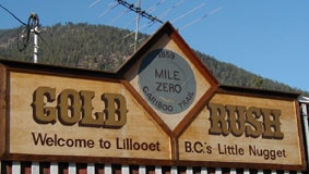
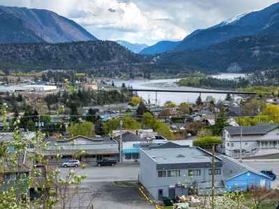
 Lillooet, "Little Nugget of British Columbia" is the regional center with a population of around 5,000 inhabitants. The first residents were self-sufficient fishermen and hunter-gatherers who lived in harmony with the seasons. Explorer Simon Fraser arrived here on June 30, 1808, after a laborious journey along the river that bears his name. Apart from a few visits from trappers, there was little activity in Lillooet until the arrival of gold prospectors in 1858.
 Lillooet was initially called Cayoosh Flat because of the good pastures that the cayuses (Indian ponies) appreciated here. Governor James Douglas named the town Lillooet in 1861, but its geography and spelling were both somewhat vague. Lillooet is a misspelling of the Indian word LEEL-wat, which refers to the indigenous people of Mount Currie and the surrounding areas.
In the 1860s, Lillooet was the second-largest settlement north of San Francisco and west of Chicago. At Mile 0 of the Cariboo Road, there was a hard and lively life with 13 saloons, 25 drinking establishments, and a population of 16,000 people.
Although the prospectors left the town for more promising horizons like the Klondike, Lillooet survived. In the 1890s, gold prospectors at the Golden Cache mine found several million dollars worth of gold. Lillooet thrived thanks to the arrival of the railway in 1912 and the discovery of gold in the Bridge River, which created another boom.
 The types of trees and plants change according to altitude and sunlight. Trees found at lower altitudes include Ponderosa pine and Douglas fir. At higher elevations, the trees gradually change to Lodgepole pine, Engelmann spruce, and Sub-Alpine fir. Trees planted in this area are primarily pine, spruce, balsam, and Douglas fir. In some wetter locations towards the coast, cedar and hemlock are also grown.
The St'at'imc Tribe
The traditional territory of the St'at'imc is approximately 100 square miles, stretching from Pavilion in the north to Port Douglas in the south. They have lived here for 9,000 years, with the Upper St'at'imc mainly staying in the northern region, including Anderson Lake. The tribe consisted of several family communities that shared the same language, culture, resources, and trade. Their economy was based on hunting, fishing, plant gathering, and services. They were semi-nomadic, traveling in the spring, summer, and fall, going where food was plentiful.
The St'at'imc had many chiefs before the arrival of the whites. The chiefs possessed the knowledge, skills, and qualities that ensured the survival of the tribe. Decisions were made by consensus for the common good. They were known for their generosity, kindness, productivity, spirituality, and also for their peaceful nature, but defended their territory and honor bravely. They were sometimes attacked by neighboring tribes. The St'at'imc language and culture survived adversity. The present and future generations continue to preserve them.
The Hanging Tree
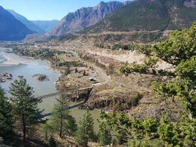
This old Ponderosa Pine was used as a gallows for administering justice more than 100 years ago. At that time, the law was Sir Matthew Begbie, better known as "the Hanging Judge." Two thieves were hanged at the same time and buried on site. In 1859, Judge Begbie wrote: Lillooet is a prosperous and beautifully placed location on the Fraser River.
Lillooet, British Columbia, Canada - Map 


Former holiday hotel with a garden along the Allier, L'Etoile Guest House is located in La Bastide-Puylaurent between Lozere, Ardeche, and the Cevennes in the mountains of Southern France. At the crossroads of GR®7, GR®70 Stevenson Path, GR®72, GR®700 Regordane Way, GR®470 Allier River springs and gorges, GRP® Cevenol, Ardechoise Mountains, Margeride. Numerous loop trails for hiking and one-day biking excursions. Ideal for a relaxing and hiking getaway.
Copyright©etoile.fr

 Lillooet, "Little Nugget of British Columbia" is the regional center with a population of around 5,000 inhabitants. The first residents were self-sufficient fishermen and hunter-gatherers who lived in harmony with the seasons. Explorer Simon Fraser arrived here on June 30, 1808, after a laborious journey along the river that bears his name. Apart from a few visits from trappers, there was little activity in Lillooet until the arrival of gold prospectors in 1858.
 Lillooet was initially called Cayoosh Flat because of the good pastures that the cayuses (Indian ponies) appreciated here. Governor James Douglas named the town Lillooet in 1861, but its geography and spelling were both somewhat vague. Lillooet is a misspelling of the Indian word LEEL-wat, which refers to the indigenous people of Mount Currie and the surrounding areas.
 The types of trees and plants change according to altitude and sunlight. Trees found at lower altitudes include Ponderosa pine and Douglas fir. At higher elevations, the trees gradually change to Lodgepole pine, Engelmann spruce, and Sub-Alpine fir. Trees planted in this area are primarily pine, spruce, balsam, and Douglas fir. In some wetter locations towards the coast, cedar and hemlock are also grown.


