


 You don't drive, you watch the landscape. And you have time to walk. How can you go for a walk in the morning, change climates, discover new paths, return home in the evening, and all without taking the slightest risk on increasingly dangerous roads? By taking a railway line with exceptional touristic appeal, which operates every day in the Cévennes region.
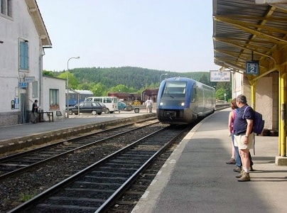
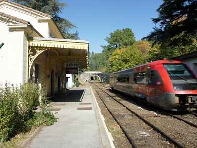
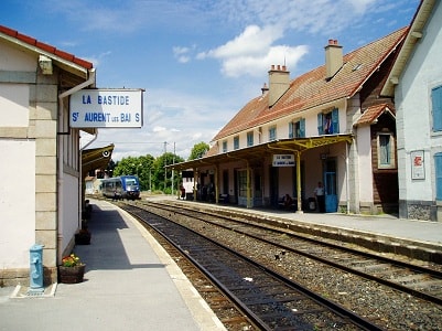
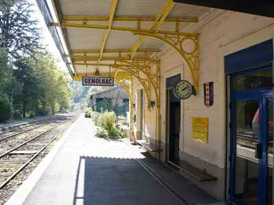
Unfortunately, the Nîmes-Clermont-Ferrand line does not receive the same promotional push from the SNCF as the TGV. Yet, it allows residents of Nîmes and Montpellier, who love peaceful hikes, to go on wonderful day trips up to 1,500 meters in altitude. You have a choice of departure (from Montpellier): 6:57 AM (except Sundays) or 7:35 AM (daily, with a connection in Nîmes). You have a choice of destination: among others, Génolhac, perched on the slope of Mont Lozère; even higher, Villefort, with its beautiful lake surrounded by the steep banks of the Chassezac Gorges. And finally, at its peak, La Bastide-Puylaurent (La Bastide-St-Laurent-les-Bains), at 1,024 meters in altitude, just a stone's throw from the triple watershed of the Loire, Rhône, and Garonne basins, taking the form of the Allier, the Chassezac, and the Lot rivers, which spring from the neighboring highlands.
 Departing at 7:35 AM, you reach these high lands, which look like a mix between Slovakia and the Massif Central, at 10:15 AM. A little more than two and a half hours by train to breathe the air of some of the most beautiful landscapes in the region. And those two and a half hours are not spent driving behind a truck. With your nose pressed against the railcar window, you discover, with every turn of the wheels, the subtle nuances of the progressively changing vegetation, from Mediterranean to mountainous. The Nîmes garrigues, then the pine forests of the Gardon valley north of Alès, the chestnut groves from La Grand-Combe to Villefort via Chamborigaud and Génolhac, and finally the highland broom, punctuated by small woods of black pines whose trunks are twisted by the harsh winters and powerful winds.
From the limestone world of the Gardon valley, we move to the schist of the slopes of Mont Lozère to finally reach the granite of Prévenchères, near La Garde-Guérin, a land of menhirs and ancient trails. Here runs the GR®700 Regordane Way, which historically linked Saint-Gilles to Le Puy-en-Velay, the Auvergne of the Black Virgins, a route that the PLM engineers decided to faithfully follow 150 years ago. The train snakes its way through one of the most complex and difficult landscapes, with gradients reaching up to 80 per thousand.
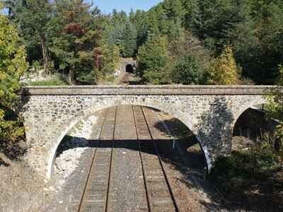
 To gain altitude just before La Bastide-Puylaurent, the train meanders along the Gardon river before reaching Sainte-Cécile-d'Andorge (which was once a transfer station for the narrow-gauge train heading to Florac). From here begins a true balancing act: gaining height by following an axis that is perpendicular to the valleys descending from Mont Lozère. An impressive sequence of tunnels and viaducts unfolds before the traveler. With two absolute highlights: the curved viaduct of Chamborigaud, offering a guaranteed view of one of the most beautiful corners of the Cévennes, and the Albespeyre tunnel, which was so high, long, and steep that it required a massive ventilation system during the heroic days of steam power.
But the train journey is not the only positive surprise of this expedition. If you ride all the way to La Bastide-Puylaurent, several major hiking routes open up to you. For a slower pace, there is the Abbey of Notre-Dame-des-Neiges, the final French retreat of Charles de Foucauld before he ventured into the desert. A solid hour's walk through woods and fields.
For the more courageous, the sources of the Allier river offer a three-hour walk with two possible routes, one of which partially borrows the GR®70 Stevenson Trail, taking you through beech and fir forests, across a ford, or through vast, sweeping highland pastures. You can also explore the menhirs, visit the thermal spa town of St-Laurent-les-Bains, or start an exploration of the magnificent Allier valley all the way to Luc.
In La Bastide-Puylaurent, there are several hotels as well as the L'Etoile guesthouse, run by a colorful Belgian host, providing accommodation from June to September. It serves as an ideal basecamp for all the possible hiking trails in this beautiful region.
The Construction of the SNCF Line for the Cévenol Train
The central section from Brioude to Alès in the Gard, within the Occitanie region, the historical capital of the Cévennes.
Following a public utility inquiry, the decree of April 9, 1862, officially declared the project in the public interest, making the concession final. The P.L.M. company harbored no grand illusions regarding local traffic on this new section and was fully aware of the tremendous technical difficulties the work would entail. However, the new section would grant them the shortest tariff distance for transporting Languedoc wines to Paris—a distance that P.L.M. on one side, and the P.O. supported by the Midi on the other, would fiercely contest with new lines and connections for nearly 50 years. As early as 1863/1864, construction contracts were awarded between Brioude and Langeac and between La Levade and Le Luech.
 Year by year, the situation of the works progressed as follows:
1864:
- Brioude-Langeac in full execution: earthworks and civil engineering structures are one-third complete.
- La Levade - Le Luech (3 viaducts and 6 tunnels totaling 2,400 meters): in full execution.
- Langeac - Le Luech: 2 out of 3 projects have been submitted. The 3rd will soon be submitted (Langogne - Villefort) in Lozère.
1865:
- Brioude - Langeac: work is highly advanced; track laying and ballasting are ongoing, as well as the interior outfitting of the stations.
- Langeac - Langogne: tunnel boring has begun; land expropriation is underway.
- Langogne - Villefort: the project is currently being submitted.
- Villefort - Le Luech: work commenced on September 1st. Progress is at 25%.
- Le Luech - La Levade: earthworks and structures are almost complete. In the La Bégude tunnel (1,728 meters), 114 meters remain to be bored and 500 meters to be vaulted.
1866:
- Brioude - Langeac: line opened on December 10.
- Langeac - Villefort: lands have been expropriated and acquired. Designs for engineering structures have been drawn up.
- Villefort - Le Luech: highly advanced. Major structures are almost finished. Track laying is about to begin, and buildings are under construction.
- Le Luech - La Levade: nearing final completion.
1867:
- Villefort - La Levade: line opened on August 12.
- Langeac - Villefort: work is being pushed forward actively.
1868:
- Langeac - Villefort: construction is advancing intensely. Out of 64 tunnels, only 3 remain to be fully bored over a length of 228 meters. The viaducts of Fontannes (with exceptionally difficult foundations), the Allier (72 meters high), and Condes still need to be completed. The other structures are finished, and the buildings are highly advanced.
1870:
- Langeac - Villefort: line opened on May 16.
 Simultaneously, the P.L.M. company adapted the facilities of the southern section, between La Levade and Alès, which until then had been a dead end, to accommodate transit traffic. This primarily involved track repairs, realignment, and the expansion of stations.
By December 31, 1870, the total expenditure for the section from Saint-Germain-des-Fossés to Alès amounted to nearly 208,000,000 francs. Converting a gold Louis to 500 francs, this represents 5.2 billion of our (old) francs! In March 1877, the journey from Clermont-Ferrand to Nîmes took 10 hours and 13 minutes by express train in all classes (subject to conditions) and 12 hours by omnibus train. In 1898, two trains ran in each direction—one omnibus and one express—covering the entire route (Clermont-Nîmes = 304 km) according to the following schedules:
- Omnibus 713: Clermont 6:55 AM; Nîmes 5:54 PM
- Express 709: Clermont 6:08 PM; Nîmes 2:22 AM
- Express 710: Nîmes 12:42 AM; Clermont 9:00 AM
- Omnibus 730: Nîmes 8:14 AM; Clermont 7:22 PM
Other trains only served partial segments of the line.
In the summer of 1914, just before the outbreak of World War I, the service had slightly expanded with two express trains in each direction on the following schedules:
- Express 921: Clermont 4:15 AM; Nîmes 12:34 PM
- Omnibus 939: Clermont 7:00 AM; Nîmes 6:00 PM
- Express 929: Clermont 4:54 PM; Nîmes 2:04 AM
- Express 922: Nîmes 12:15 AM; Clermont 8:33 AM
- Omnibus 950: Nîmes 7:50 AM; Clermont 7:15 PM
- Express 930: Nîmes 12:28 PM; Clermont 9:25 PM
 In Clermont-Ferrand (altitude 358 m), the station is located in the lowlands below the city, but the route through the Limagne plain quickly offers views of the promontory dominated by the cathedral spires, followed by the rounded summit of the Puy-de-Dôme. At Martres-de-Veyre, the line meets the course of the Allier River. The river is accompanied sometimes on one bank, sometimes on the other, until nearing Arvant. Just before temporarily leaving the river, the line serves the Brassac coal basin. The P.L.M. network operated a factory here to manufacture briquettes (agglomerates) from small pieces of coal, tar, and pitch, delivered in the shape of small cylinders; these agglomerates replaced the briquettes often marked "Aniche" used by other railway networks.
Through the valley of a tributary of the Allier, the line reaches Arvant, where the route towards Neussargues - Le Lioran - Aurillac - Capdenac, studied and established by the Grand Central company, branches off. Near La Roche-Fougère, a platform emerges on the western side; this is a connection to the line from Brioude to Saint-Flour, which was part of the shortest tariff route for wines from the Midi to Paris. The platform is still waiting for its tracks, and the mainline that connected the Cévenol route to Beaumont-Lauriat has long since been dismantled.
 We are now in Brioude, which hosts an annual railway film festival. The line returns to the Allier to cross it at the Bageasse viaduct, and then, at Feugières-le-Pin, it meets one of its tributaries, following its course up to the main line. Here is the junction station of Saint-Georges-d'Aurac, connecting to the line from Le Puy-en-Velay in Haute-Loire and Saint-Étienne in the Loire.
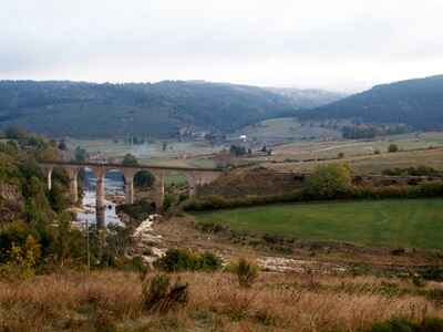
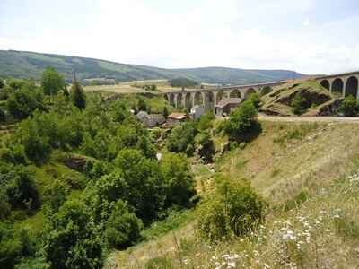
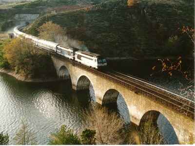
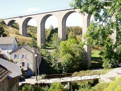
From Clermont-Ferrand, the gradients had not exceeded 10 mm/m. A gradient of 12 mm/m now allows the train to reach the Allier, crossing it at the Costet viaduct (216 m). The line will not leave the river again until La Bastide-Puylaurent in Lozère. We serve Langeac (altitude 504 m), once the logistics hub for trains on the Le Puy-en-Velay line. After Chanteuges, the truly spectacular section of the route begins. The Allier valley narrows progressively, transforming into a deep gorge. From retaining walls to tunnels, and from tunnels to viaducts spanning the Allier or its tributaries, the line first climbs to Langogne (altitude 911 m), where another, unfortunately closed, line from Le Puy-en-Velay branches off. On this stretch alone, the line crosses 8 major viaducts (including the famous one at Chapeauroux) and a staggering 49 tunnels!
Furthermore, from Prades-Saint-Julien to Langogne, no road follows the gorges. Only the railway track, with a maximum gradient of 15 mm/m, allows passengers to discover the wild beauty of this high valley with its steep walls, catching passing glimpses of several heavily ruined medieval castles.
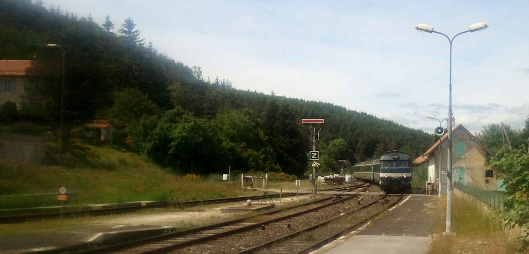
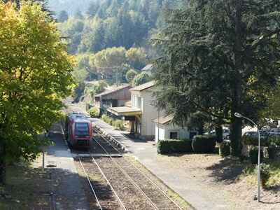
From Langogne to La Bastide-Puylaurent (altitude 1,023 m - junction to Mende and Marvejols), the terrain becomes less harsh, and the N106 highway shares the valley with the railway line and the river via Luc. In La Bastide-Puylaurent, the snow is more famous for the massive clearing work it requires than for the joys of skiing. We leave the Allier to find its source, and now the descent from the Cévennes begins via Prévenchères. And what a descent: a drop of 25 mm/m down to Villefort (altitude 605 m), 10 mm/m down to Concoules-Ponteils (583 m)—a station serving two widely separated villages—and again a drop of 25 mm/m down to Chamborigaud (329 m). A slight climb and a long tunnel, followed by a maximum descent of 22 mm/m, finally lead into the Gardon valley at Sainte-Cécile-d'Andorge (formerly the junction for the narrow-gauge railway to Florac).
 The southern, Mediterranean side of the line is vastly different from the northern section. Here, there are no long, continuous gorges; following the extremely winding, torrential rivers with their irregular flows would have been completely unfeasible. Only the Chassezac is an exception, and only for a short distance. Therefore, the railway line tackles the mountains from the side, cutting through chestnut forests, weaving in and out of every crevice, and frequently crossing perpendicular to the rivers. The result: from La Bastide-Puylaurent to Sainte-Cécile-d'Andorge, the traveler passes through 42 tunnels and crosses majestic viaducts: over the Chassezac near Prévenchères, the Altier at Villefort, the Malautière near Concoules, and the Luech at Chamborigaud. The Albespeyre tunnel (1,504 m), featuring a 25 mm/m gradient between the stations of Prévenchères and Villefort, required the constant operation of a powerful ventilation plant during the steam era.
This brief description naturally cannot exclude a profound tribute to the builders and engineers who constructed it all using only the technical resources available during the Second Empire.
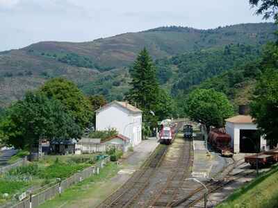
 We are now in the Gardon valley, which is quite narrow in places and dotted with a few tunnels. We are in the heart of a former coal basin, centered in Alès (altitude 135 m). The operation of the so-called "Alès star" network, serving the mines and the regional industries—especially chemical and metallurgical—once gave immense importance to the station. However, the depletion of the coal basin has inevitably led to a massive reduction in the railway facilities.
We leave the Gardon valley at Nozières-Brignon. The line crosses a few viaducts and climbs slightly to traverse the hills overlooking Nîmes, which on their southern side form the very dry Nîmes garrigue. A gradient of 12 mm/m brings the train from Mas-de-Ponge (altitude 147 m) down to the facilities at Courbessac, from where the train reverses (rebroussement) into the Nîmes-Voyageurs station.
This peculiar entry maneuver is due to historical reasons. The original line from Alès to Beaucaire served Nîmes where the current freight station and depot are located. When the Mediterranean lines merged, a new passenger station was built on a viaduct between the lines from Beaucaire and Montpellier. Naturally, it would have been possible for the train to bypass Nîmes to the west, but the cost of such extensive engineering works was deemed too high. Maintaining the status quo, with the train reversing into the station, was preferred.
So do not hesitate any longer. Grab a ticket, take a tourist map in hand, and treat yourself to a journey on the Cévennes line. You will not regret it, especially if you enrich the trip with a stay in one of the villages along the route. You will rediscover the joy of a peaceful life in the fresh air, and you will undoubtedly find that perfect little spot that allows you to take magnificent railway photographs.
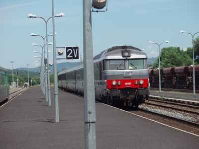
From Auvergne to Languedoc with "Le Cévenol" train
 Improved over the years, the Cévenol, now a lively modern regional train, connects the shores of the Mediterranean to Paris by taking a route that literally defies nature, particularly through the gorges of the Allier.
The train bears the name of the wild mountains it crosses, the southern foothills of the Massif Central, and helps raise public awareness of the Cévennes from spectacular angles completely unknown to motorists.
The extreme south of the Cévennes contained significant coal deposits, providing coal of excellent quality. However, exploiting these deposits presented serious difficulties. The coal seams were most often located on the mountainsides in deep, enclosed, and remote valleys. In addition to the challenges posed by the harsh relief, there was a lack of flat areas to establish the necessary facilities: sorting, washing, storage, etc. Production suffered greatly from this situation, and sales only modestly recouped the investments and efforts of the financiers and operators. Furthermore, the extracted tonnage was incredibly difficult to transport and sell: at the beginning of the 19th century, the road network in the mountainous Cévennes was extremely sparse. It was heavily traveled by animal-drawn carts whose combined weight was substantial, and road maintenance left much to be desired.
 Natural phenomena such as droughts, heavy rains, severe floods, and landslides greatly increased the difficulties. Finally, the transport of coal, which required numerous carts, horses, and personnel, burdened the price of the fuel with prohibitive transport costs. This made it completely impossible to compete with foreign coal arriving by ship directly at coastal ports.
The mine operators naturally could not alter the physical landscape of the deposits. At best, they could make very costly improvements to the existing roads. But they learned that further north, in the Forez region (near Saint-Étienne), other operators facing similar natural conditions had adopted a new English invention—the railway—to transport their production to navigable waterways.
The management of the Mines de La Grand'Combe (Messrs. Talabot, Veaute, Abric, and Mourier) followed the example of their predecessors and applied for the concession of a line from Alès to Beaucaire via Nîmes to connect their deposits directly to the Rhône River and its navigation canals. The State required a bidding process, preceded by an inquiry, based on the proposed transport tariffs. The bid from Mr. Talabot and his partners (0.17 francs per ton-kilometer uphill, 0.10 F per t/km for coal, and 0.15 F for other goods downhill) was accepted. A law passed on June 29, 1833, granted them a perpetual concession for the line, which was originally intended solely for freight transport. A royal ordinance on October 19, 1835, approved the exact routing.
 While the railway thus granted greatly improved service to the coal basin, it did not cover the entire area. A second concession—this time limited to 99 years—concerned a line from Alès to the mines of La Grand'Combe, which was open to both passengers (0.12 F/km) and freight (0.17 F/t.km uphill and 0.15 F downhill). The ordinance of May 12, 1836, thus brought the railway into the immediate vicinity of the mine shafts. In 1839, there were 6 active mines in the mountains of La Grand'Combe and 5 in the Abylon mountains—in Trescol, La Levade, Champclauson, and Saint-Jean-de-Valériscle.
Executing the railway construction works was fraught with difficulties. Only the section from Nîmes to Beaucaire, built over flat terrain, was ready and opened to traffic on July 16, 1839. Initially, it served only passengers (averaging 500 per day), while freight traffic was gradually organized towards the end of the year. It is highly likely that the company was already transporting its own coal between Grand'Combe and Alès by late 1839. Passenger transport between those towns was established in late February 1840. The official inauguration of the section from Alès to Nîmes took place on August 19, 1840. Coal could then reach the banks of the Rhône in large quantities, but on November 3, 1840, a breach in the river dikes flooded the entire delta, rendering the shipping ports of Beaucaire temporarily useless. North of Alès, public traffic was finally and permanently organized—according to statistics from the Ministry of Public Works in January 1841 and P.L.M. documents on October 25, 1841—up to La Verrerie (La Grand'Combe) and La Levade (Trescol).
 In the summer of 1847, there were 4 passenger trains between Nîmes and Beaucaire (1st, 2nd, and 3rd class), but only 2 trains with 4 classes covering the journey from Alès to Nîmes, which took two hours. Between La Levade and Alès, we find no trace of published schedules, and it must be assumed that the transport of miners and local travelers was carried out using freight trains. Until 1849, passenger transport in Alès was handled at two separate stations: one for Nîmes and one for La Levade. Since the operations between La Levade and Beaucaire remain relatively unknown, it is interesting to shed some light on the rolling stock of the era.
The constant fluctuations in these numbers testify to a railway operation that was still finding its footing. To standardize it, experts in the railway field had to intervene. This was one of the primary goals of an early, major merger: by an agreement on June 19, 1852, the Chemin de fer de Lyon à Avignon company purchased all the railways in the Gard department for 30,000 bonds at 4% interest, valued at 1,000 francs each. These bonds, issued by the newly formed Lyon à la Méditerranée company, were repayable over 99 years and supplemented by additional securities based on the net profits of the various acquired lines. A second agreement, concluded the same day between the Ministry of Public Works and the Lyon à la Méditerranée company, and formally approved by law on July 8, 1852, authorized the transfer and unification of the concessions.
 To the North: The territory of the Grand Central company
The concessions granted by the State to the Compagnie du Centre (which merged with Paris-Orléans, P.O., in 1852) stopped at Clermont-Ferrand. The Grand Central company, chaired by the powerful Duke de Morny (half-brother to Napoleon III), wanted to expand these concessions by creating East-West lines from Bordeaux to Lyon and North-South lines, notably a direct link between Clermont-Ferrand and Montauban.
The French government, however, reserved these overly ambitious projects for the future. By an agreement on March 30, 1853 (approved by imperial decree on April 21, 1853), the State limited the concessions in our area of interest to:
- A line from Clermont-Ferrand to Lempdes (granted as a final concession).
- A line from Saint-Étienne to the Montauban-Lot River line (granted as a potential concession).
The first line, for which preliminary studies had already been carried out, was immediately put under construction for a fixed price of 136,400 francs per kilometer by the engineer Mr. Julien Lacroix.
 As the work progressed rapidly, a new agreement on February 2 and April 6, 1855, approved by decree on April 7, 1855, and sanctioned by law on May 2, 1855, made the potential concession of 1853 final and binding.
On July 2, 1855, Grand Central trains began operating between Clermont-Ferrand and Issoire. The route included a 4 km long branch line directly serving the Bourdon sugar factory, a massive industrial enterprise owned and managed by Morny himself.
On September 3, 1855, the tracks reached Brassac and its important coal mines, served by a 1-kilometer branch line. On May 3, 1856, the trains arrived at the station in Arvant.
The Grand Central company also continued construction towards Brioude as part of the planned Bordeaux-Lyon connection. However, the company, led by Morny, had spread its investments and efforts far too thin over a massive, unprofitable, and highly difficult network to build. A victim of a severe financial crisis, Grand Central was forced to collapse and cede its concessions partly to the newly formed giant P.L.M. (Paris-Lyon-Méditerranée) and partly to the P.O. (Paris-Orléans). A comprehensive treaty on April 11, 1857, settled the division of the lines. P.L.M. inherited the Clermont-Ferrand to Brioude line, which opened on May 1, 1857, as well as the access route towards Saint-Étienne. Beyond this point, no work had yet begun towards Saint-Georges-d'Aurac.
That same day, the Ministry of Public Works signed a treaty with P.L.M. representatives officially approving the division agreements. Since the State always tied the acceptance of new, profitable concessions to the requirement to build new, less profitable lines, P.L.M. received, among other lines, the potential concession for a railway from Brioude to Alès. The routing of this new line had to be carefully coordinated with the planned line from Brioude to Le Puy-en-Velay (and on to Saint-Étienne). The decree of June 19, 1857, definitively approved the treaty, and P.L.M. formally took over its share of the remnants of Grand Central on July 1, 1857. The highly contested boundary between the P.L.M. and P.O. networks was thus, after many political and economic twists, finally settled.
SNCF schedules: SBB schedule, SNCF-Occitanie ![]()