


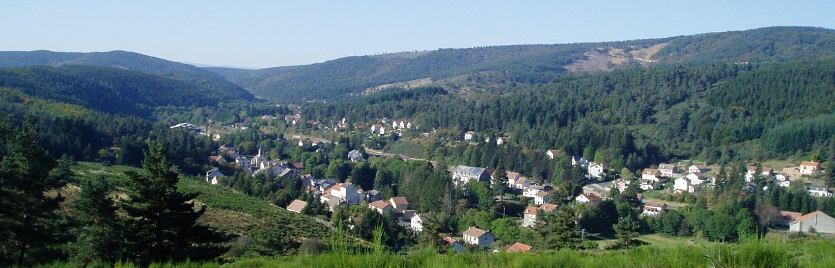
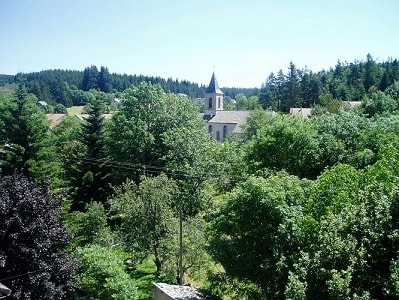
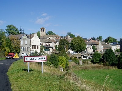
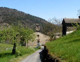
 An early morning departure under a bright sun as the beautiful weather settles in. Upon leaving La Bastide-Puylaurent, the Stevenson Trail quickly returns to the vast, open spaces of the Gardille forest, which I had crossed just two days prior. The wind sweeps across the plateau, its mournful music permeating the immense solitude. Why is it that such isolation can feel exhilarating one day and anxiety-inducing the next? The Stevenson path drops back into the valley for a final encounter with the young Allier River. The Chassezac also carves its first meanders here. A few hamlets are scattered along the valley. I fondly remember a lovely hollow carpeted with daffodils and the robust, harmonious Romanesque church of Chasseradès... Inaccessible, alas, like so many others! A consequence of our modern era of vandalism and insecurity; these urban scourges reach even the depths of remote lands one would think preserved. Ah! Bless the priest of Chanteuges who, against all odds, maintains the hospitality of his admirable abbey and even enhances it with sacred music!
 The afternoon brings another long wandering through the rolling hills of the Goulet mountain and its immense conifer forest. On the southern slope, I witness a new birth: the Lot River emerges in the heart of the forest massif, taking its first steps in a lovely valley welcomed by birches, gorse, and daffodils. Three very different destinies for three rivers born in the same massif; the Allier merges its fate with the Loire and ends its long journey at the borders of Brittany; the Chassezac and the Ardèche wind through deep, wild gorges on their way to the Mediterranean shores; and the Lot flows into the Garonne to mingle with the rich Bordeaux vineyards near the Atlantic. The chance placement of a valley or hill, and their destinies diverge. So it goes for children of the same household. A 25 km stage.
Today, I enter the "Land of the Camisards." Finally, I must say; my deep attachment to the Cévennes is closely tied to my sympathy for these unyielding defenders of their faith. Leaving Le Bleymard and the Lot valley, the trail climbs the northern slope of Mont Lozère. A rather steady ascent leads to the Mont Lozère station (1,421 m). You then reach the barren summit and climb along the draille. (While they now bring joy to hikers, for many centuries, drailles served as transhumance routes for flocks of sheep moving from the southern plains to the Causse Méjean, Larzac, Tanargue, and Mont Lozère. Pierre A. Clement has dedicated an exciting book to them, En Cévennes avec les bergers. This historian from Languedoc traveled five of these mythical routes in the company of shepherds. And he describes this experience in savory tales, where hikers who have crisscrossed the Cévennes will certainly recognize many notable places.)
 These trails are marked by montjoies (tall granite markers, like those lining the draille on Mont Lozère, or stone assemblages). Their primary function was to mark transhumance routes, much like the cairns hikers know well from the Pyrenees. However, the guidebook notes that some montjoies date back to the Middle Ages and may have defined territorial boundaries. Thus, the Maltese crosses carved on some upright stones in Lozère may have marked the properties of the Knights of Malta... I especially noticed the modern, iconoclastic 'tags'! It is the kingdom of the wind, sweeping across the moor of stones and short grass. The hiker braces against it until reaching the summit of Pic de Finiels (1,699 m). It is the highest point of the massif and of my trek. All around, the infinite undulations of ridges and valleys fade into a bluish mist; to the north, memory revisits recent stages; to the south, imagination envisions the paths ahead. The mind wanders in this high-altitude solitude (shared briefly, as a hiker from across the Rhine caught up with me).
 But our paths part quickly. The GR®70 offers an almost uninterrupted descent towards Finiels and Pont-de-Montvert. It is a somewhat abrupt... and frustrating end to the stage. The weather is glorious, and a few years ago, during an Easter hike, I promised myself I would return to admire the blooming gorse of Lozère. The opportunity is too good to pass up. I cannot resist taking a long detour via the GR®7. After the Finiels pass, the Languedoc draille feels a bit lengthy along the old Roman road; but what enchantment when the narrow path tilts onto the southern slope of the massif! It plunges alongside a stream, winding between granite boulders and weaving through the golden gorse...
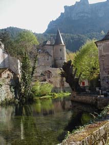
The draille continues its peaceful descent through old deserted hamlets (Salarial, l'Hôpital) and reaches Pont-du-Tarn. The site lives up to my memories—and even surpasses them in the heart of spring, as the clear water sparkles and sings over the rocks. My lunch break is an idyllic moment of this hike. Now, I turn onto the GR®72, which easily rivals the GR®7; for a few kilometers, it skirts the river as it rushes in torrents over rocky debris. The path then tumbles down through thickets of gorse spiked with granite chaos. Felgerolles, Le Merlet... and then the enchantment fades upon reaching the departmental road leading to Pont-de-Montvert. A short half-hour of asphalt is a small price to pay for such a long, exhilarating journey. A 30 km stage.
 Pont-de-Montvert is a key historical site in Camisard country. The temple, featuring a wooden pulpit of majestic simplicity, still attests to the vitality of the Reformed faith. But how can one imagine that this beautiful and peaceful village was, in 1702, the birthplace of the dramatic events (the assassination of Abbé du Chayla and the subsequent execution of the main rebel leader, Pierre Séguier) that triggered such a terrible war? (On July 24, 1702, Abbé du Chayla was assassinated in Pont-de-Montvert by a group of Protestants demanding the release of their imprisoned co-religionists.
Abbé du Chayla, the former priest of Saint-Germain-de-Calberte, had been condemned by the Church for embezzlement but was nevertheless promoted thanks to his family and political connections. He was tasked with the "muscular" evangelization of the Cévennes. His brutal zeal sparked intense hatred among the Protestants, which reached its breaking point on that fateful July evening in 1702. Quickly arrested and judged as the leader of the assassins, Pierre Séguier—nicknamed "Esprit" Séguier for his inspired sermons—was condemned to have his hand cut off and to be burned alive at the exact spot where his victim perished, right in front of the clock tower of Pont-de-Montvert. Thus began a brutal two-year war that would set the Cévennes ablaze. Jean-Pierre Chabrol beautifully evoked these terrible years in his novel Les Fous de Dieu. Just one quote: "I drank, lips in the foam of the stream, while my soul quenched its thirst for the purity of kneeling like this, in the watercress of a spring rather than on the prayer desk of a chalk Saint Joseph, and kissing the water of the snows rather than the ring of a bishop."
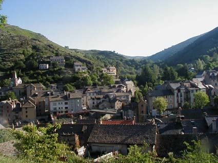
 Today's stage on the GR®70 does not follow the historical route to Florac. "A new road," wrote Stevenson, "leads from Pont-de-Montvert to Florac, through the Tarn valley. Its soft sandy bed develops approximately halfway between the peaks of the mountains and the river at the bottom of the valley." (Travels with a Donkey in the Cévennes). Today, this is the D998 that winds along the Tarn. There is no question of a hiker enduring twenty kilometers of asphalt and road traffic! Instead, the GR®70 offers Stevenson's followers the solitude and high-altitude landscapes he missed. Barely leaving Pont-de-Montvert via a beautiful cobbled path, the Cham de L'Hermet overlooks the village stretched out in a hollow of hills at the confluence of the Lot, Rieumalet, and Martinet. Then, on the slope of Bougès, it is an ascent into a cathedral of conifers, accompanied by the wind's great organs. At the Col de la Planette begins a long trek across the bumpy spine of the Bougès mountain. It peaks at the Signal du Bougès (1,421 m), its dome crowned by a monumental cairn. It is a magnificent viewpoint. I am taking my revenge on a dreadful day in April '95, which was nothing but a rushed, blind march; rain and fog erased all these landscapes that are offered today under an azure sky—from Mont Lozère to the Mimente valley and the cliffs of the Causse Méjean. In the past two days, I have reached the absolute summits (geographical, aesthetic, and mental) of my trip. Ah! If only I could prolong this state of freedom, serenity, and peace... At the end of this beautiful journey, the plane-tree-shaded terraces of Florac exude a deeply southern charm, just steps from the source of the Pêcher... A 25 km stage.
 This Sunday morning, Florac is still asleep as I wander its deserted streets. I have another solid stage ahead towards Saint-Germain-de-Calberte. With the GR®70, I quickly turn my back on the cliffs of the Causse Méjean and enter the Mimente valley. The increasing altitude and dense forest soon drown out the noise of motor traffic. I am back in wild nature, in the heart of the chestnut Cévennes. Robust, gnarled trunks with sculptural forms colonize the hillsides. Startled as much as I am, a doe darts away with a crash of branches. At Saint-Julien-d'Arpaon, I descend to cross the river and embark on a long, peaceful, and charming trek along the old railway line; today, it is a pleasant, grassy, flower-lined path following the valley's meanders high above the emerald ribbon of the Mimente. At Cassagnas, the weather is radiant, inviting laziness... Why rush when barely a dozen kilometers remain? But I must "get going" and regain the heights. The path climbs back into the forest; the slope is comfortable and does not spoil the joy of walking. The stele raised in memory of the Camisards at the Plan de Fontmort is well worth a short detour on the GR®7 / GR®67 coming from Barre-des-Cévennes. "Not far from this place, on my right, stood the famous Plan de Font Morte where Poul, with his Armenian scimitar, massacred Séguier's Camisards."
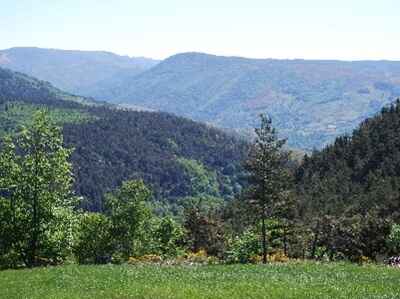
 It was here that Captain Poul ambushed "Esprit" Séguier and his troop of Camisards. Following the battle, the murderer of Abbé du Chayla was captured by the king's soldiers and taken to Florac for trial. This historic site is marked by a stele, a modest obelisk commemorating the heroic devotion of the Cévenol Huguenots to the Reformed faith. Stevenson, the Scottish author, indulges in some astute reflections: "I smiled thinking of Baville and his dragoons, and that one can trample a religion under the rough hooves of horses for a century and leave it even more alive after such a trial. Ireland is still Catholic; the Cévennes are still Protestant. A full basket of laws and decrees, no more than the hooves and mouths of cannons from a cavalry regiment, can change an iota of a farmer's freedom of thought...". The GR®70 now follows in their footsteps along the old royal road cut into the hillside. This strategic route was carved directly into the schist slopes to move troops through the Cévennes mountains. Today, this beautiful balcony path serves a more peaceful purpose; the hiker enjoys a continuous spectacle, with an immense panorama stretching over the undulating crests of the ridges (serres), beyond the maze of the gardons, all the way to the bluish horizon of Mont Aigoual. In this late southern afternoon, the forest exudes the warm scent of resin... A 28 km stage.
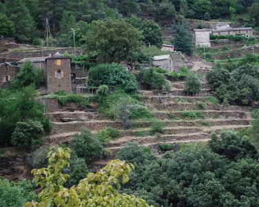
 Saint-Germain-de-Calberte has erected an impressive monument in its small square, honoring the Cévenol people who tirelessly shaped their mountain landscape. Walking through these hills, one better understands the immense labor required to carve out roads and convert steep slopes into arable land using bancels or faïsses (terraces). (In Les Hommes de la route, André Chamson recounts the grueling work of peasants who sold their labor to build mountain roads just to supplement their meager income. And J.P. Chabrol describes the construction of these terraces: "When one sees the work done by our great-grandparents, one is astounded by the sheer amount of pain, patience, and sweat it demanded. To create these narrow plots from scratch, they had to pry out boulders, carry retaining stones up from the river, and haul soil in banastous (baskets) to fill the gaps. All this just to plant three or four more vines... I saw a farmer build a dry-stone wall forty meters long and two to three meters high, filling the space behind it with earth carried entirely on his back... I finally understood the Cévenol's fierce attachment to his land.").
Wandering through the village streets, I spot these terraced staircases clinging to the steep hillsides. As I approach the end of my journey, I gradually leave the airy ridges behind. I descend into the maze of torrents—the gardons, as they are called here: I've looked down upon the Gardon de Saint-Germain, passed its confluences with the Gardon de Saint-Martin-de-Lansuscle and the Gardon de Saint-Étienne. The heat grows heavy, thick, and stormy. But these lower valleys remain firmly Huguenot land; along the path, I notice graves erected in private gardens—since "heretics" were banned from Catholic cemeteries, they buried their dead on family estates.
 The Col Saint-Pierre, reached after a steep, sweltering climb up the royal road, marks the border into the Gard department. I enjoy a final snack in Lozère beneath the giant chestnut trees at the pass before scrambling down the rocky trail toward Saint-Jean-du-Gard. I savor this final navigation through the frozen waves of the serres, swimming in an ocean of greenery (the light green of chestnuts, the dark green of pines) shrouded in a bluish mist. Very rarely does a red-tiled roof break the surface; are they solitary sailors or adrift castaways?
And finally, Saint-Jean-du-Gard: a deeply southern town spread along the banks of the Gardon, almost in the plains at an altitude of just 189 meters. Plane trees and palm trees give its terraces a distinctly Mediterranean feel. A 22.5 km stage. Today, I am completely alone again; Ursula has turned back toward the hills, Les Ayres, the Col de Jalcreste, and on to Florac. Farewell, then! On the agenda: a very short stage mostly dedicated to visiting two museums. First, in Saint-Jean-du-Gard, the "Cévenol Valleys Museum" strikingly reminds me of the "Museum of Walloon Life" in Liège, Belgium. It is fascinating to see how, hundreds of kilometers apart, rural life in the past relied on such similar tools and utensils, inspiring identical gestures.
 But here, I also discover the monumental role of the chestnut and mulberry trees in Cévenol civilization. The "bread tree" (chestnut) was long a vital resource: chestnuts fed humans and livestock alike; its wood served as building material, its foliage as bedding, and the Camisards even hid in its hollowed trunks. It is no surprise that royal armies systematically burned the Cévenol forests to starve the Camisards into submission. And the mulberry tree, well into the early 20th century, provided a degree of prosperity in the southern valleys thanks to the "gold rush" of silk. (Anna Rey recounts her mother's life in Augustine Rouvière, Cévenole. Her heroine recalls: "Before the 1914 war, we weren't too unhappy in my sweet valley. It was the Cévennes... Yes, our valley was good! And then there were the magnans [silkworms]. That is what brought wealth. It was always after selling the cocoons that we could finally pay our taxes. Every Cévenol planted mulberry trees and raised silkworms. The twisted stumps of the mulberries reached up to the winter sky, slowly replacing the vineyards. In good years, we produced thirty to forty kilos of cocoons per ounce of seed, and they paid about one hundred and fifty francs.").
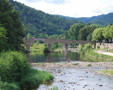
I joyfully revisited the beautiful Camisard Bridge in Mialet, its elegant arches spanning the crystal-clear waters of the Gardon. But after crossing these hills where the memory of the Camisards is omnipresent, I most wanted to visit the "Musée du Désert" at Le Mas Soubeyran. In this hamlet, the birthplace of the famous rebel leader Pierre Laporte, known as Rolland, has been ingeniously transformed into a museum by incorporating several adjoining houses. It serves as the true memorial of Protestantism in the Cévennes, manifesting a profound reverence for Liberty. The proud Cévenols, executed as heretics, refused to settle for mere "tolerance"—a condescending concession to a despised belief. They demanded absolute freedom of conscience, the right to believe and worship on a perfect footing of equality. "Récister" (Resist): this was the motto carved into the stone by a Cévenole woman imprisoned in the infamous Tour de Constance in Aigues-Mortes while her husband rowed in the royal galleys. The spelling may have been flawed, but the nobility of the sentiment was flawless. This ideal is not an empty word in these mountains; during World War II, the Maquis were highly active in the Cévennes, which served as a safe haven for German and Austrian dissidents and countless Jewish refugees. Several residents of Saint-Germain-de-Calberte earned the title of "Righteous Among the Nations" for their bravery. A 12 km stage.
 R.L. Stevenson left his donkey, Modestine, in Saint-Jean-du-Gard and took a stagecoach to Alès. I, however, am extending his journey on foot. Onward to this final stage! But it will not be a simple, quiet stroll through the plains. Via Mialet, I return to the hills following the GR®67 markers. Beyond Les Aigladines, past the Col d'Uglas, the GR®44D initiates a true roller-coaster ride along a lengthy, bumpy ridge. I face nearly 700 to 800 meters of elevation gain, scrambling through the garrigue; the path, as rocky and twisted as any I’ve seen since Brioude, snakes along the crest of the Malabouisse woods through a dense tunnel of holm oaks, boxwood, and laurels. It climbs and plunges through a chaos of limestone boulders. Immense solitude; all day long, not a single soul crosses my path in the mountains. At most, a stray tile roof peeks out far below in the Galeizon valley, blurred by the mist of a humid, stormy day. It is a slightly anxious solitude... I am nearing my goal, but with mixed feelings. A hint of apprehension lingers: a stupid accident is always possible in this loose rock and chaotic terrain. Simultaneously, do I really want this long trek to end? I'm not so sure... I just finished my final snack at the summit of Montcalm. Down in the plains, the urban sprawl of Alès appears, hazy yet undeniable; I still have a good hour's descent from these beloved mountains. Ending a wilderness hike in a large city is a jarring experience. The first sound: a police siren. The first sight: a massive public housing block. A brutal reentry into the human anthill. A 25 km stage.
I savor a beer on the terrace of the "Mal Assis" in the pedestrian center of Alès. Nostalgia is already taking hold of me. This feeling is not new at the end of a long hike, but today it strikes with particular sharpness—the beautiful adventure is truly over. I will soon be reunited with my loved ones... but also with all the daily constraints of normal life. I must not let the memories, the images, the sensations, the emotions, and the thrill of free thought fade too quickly. I must "resist" the grinding wear of everyday routine; after all, doesn't true freedom reside more in the mind and heart than in the mountain air? by Jean Marie Maquet