


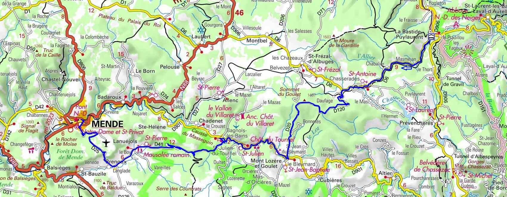
Take the D6 road along the Allier River, passing through Les Huttes, Masméjean, the Château de Chabaleyret, Chabalier, Chasseradès, and Mirandol. Just 1.1 km further on, turn left onto the D120 toward L'Estampe, then take the D20 at the summit of the Goulet mountain. This small road, facing Mont Lozère, descends to the D901 just before Le Bleymard. Turn right and follow the Lot River on the D901 to Bagnols-les-Bains, passing through Saint-Jean-du-Bleymard, the Château du Tournel, and Saint-Julien-du-Tournel. In Bagnols-les-Bains, cross the Lot and follow the D41 to Langlade via the Col de la Loubière and Lanuéjols. In Langlade, turn right onto the D25 to Mende via La Croix Neuve. Cross Mende via Boulevard Bourillon, Allée Piencourt, and the Pont de Berlière spanning the Lot, then turn left at the roundabout to reach the train station (Train schedules).
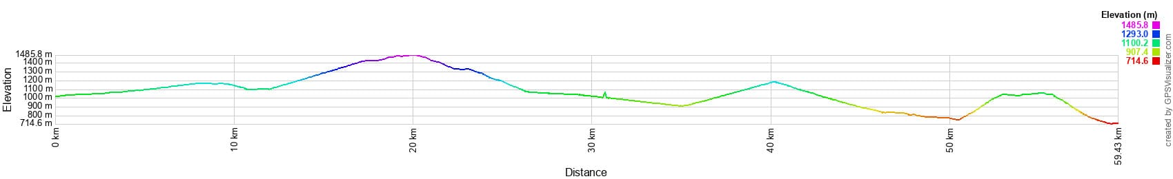
 Distance: 59.4 km. Maximum altitude: 1,475 m. Minimum altitude: 710 m. Total elevation gain: 1,193 m.
IGN Maps: Mende (2638E). La Bastide-Puylaurent (2738E). Le Bleymard (2738O). Mont Lozère Florac PN des Cévennes (2739OT). Largentière, La Bastide-Puylaurent, Vivarais Cévenol (2838OT).
Print the route - Electric bike rental
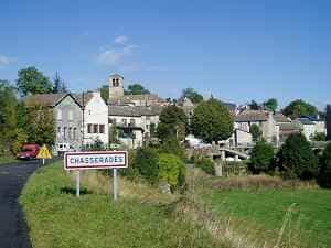
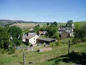
To the southwest of Chasseradès stood the Castle of Mirandol, whose name proudly reflects the sweeping views it once commanded. It was the seat of an important lordship—one of the twelve foundational domains of Gévaudan. During the Romanesque period, it was held by the "ancient knighthood of Naves." In 1207, Guillaume de Naves served as a co-lord (parier) of La Garde-Guérin, while Guérin de Naves, Lord of Mirandol, is recorded witnessing an oath of homage to Guigues, Baron of Tournel, in 1267. Slightly further west, along a narrow paved road marked by ancient granite crosses, lies the village of Saint-Frézal-d'Albuges. The scenic train connecting Mende to La Bastide-Puylaurent via Allenc and Belvezet still stops at the small station located about a kilometer from Chasseradès. In winter, snowdrifts frequently block the line, which necessitated the construction of protective snow sheds. This charming, inexpensive mode of transport is unique in France, and conveniently allows you to bring your bicycle aboard. To request a stop, simply stand on the platform and wave to the driver. Nearby, the impressive Mirandol viaduct spans the Chassezac River, which begins to carve a small canyon here before deepening into majestic gorges further downstream near La Garde-Guérin. Like the Allier, the Chassezac traces its source back to the heights of the Moure de la Gardille along the watershed line.
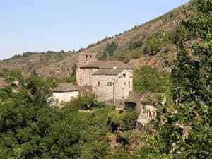
The Mende museum houses a striking print drawn by Romanet in 1780. The portrait depicts a man in his sixties with graying, curly hair styled in the fashion of Louis XVI. His broad forehead and direct gaze convey a strong, commanding personality. At the bottom of the portrait, the artist included a coat of arms featuring a pear tree (in local patois: perie) set against a gold background. This is the crest chosen by Guillaume Périer upon his ennoblement around 1745. He later became the last Lord of L'Estampe and the final bearer of the title Baron of Mirandol. A verse at the bottom of the painting offers a glowing tribute: "Good father, good relative, good citizen, good master. Having what is rare to have: good friends, and knowing how to be one." Two centuries later, the small village of L'Estampe, nestled in a limestone fold of the Goulet mountain, still harbors the ruins of what locals call "the castle." Despite the ravages of time, revolutions, and pillaging, remnants of this once-splendid residence survive, documented in scattered archives across Lozère, Gard, the Grand Séminaire de Mende, and in the private collections of residents in Chasseradès.
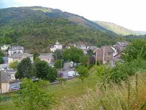
Le Bleymard, situated off the road connecting Mende to Villefort at the foot of Mont Lozère, sits at an altitude of over 1,000 meters. It is one of the quietest cantonal capitals in Lozère, largely untouched by bustling social life. Its tranquility is occasionally interrupted on winter Sundays by skiers, though most prefer to bypass the center for the Auberge de la Remise on the main road. However, it was not always this quiet. In the 16th century, Le Bleymard was a vital stopover on the road linking Mende to the Vivarais region, near the mountain pass crossing the Lozère mountains. A 1567 document notes that the village was home to many inhabitants, "both literate people of quality and craftsmen, as well as others of lower condition." A nascent local society revolved around the Sabran family—lords of Les Alpiers and prominent magistrates, several of whom served as bailiffs of Gévaudan. While the tone of this community was likely serious, the frequent passage and quartering of troops during the Wars of Religion undoubtedly disrupted the village's peaceful rhythm.
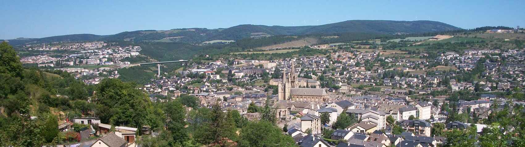
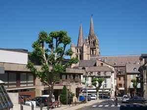
Mende, the historic capital of Gévaudan, has been the seat of the Mimatensis bishopric since the 10th century, following the fall of Javols. The current city was founded in the 5th century around the tomb of Saint Privat on the banks of the Lot River. Today, Mende serves as the capital of the Lozère department, situated squarely in its geographical center. Over the span of a century, while Lozère's overall population declined by half, Mende saw its population grow from 8,000 to 12,000 residents, largely absorbing inhabitants from the surrounding rural villages. The city is bisected by the Lot River, which rises near Le Bleymard and carves its way through nearly the entire department. The river's fertile valley brings a measure of agricultural wealth to the municipalities it traverses.