


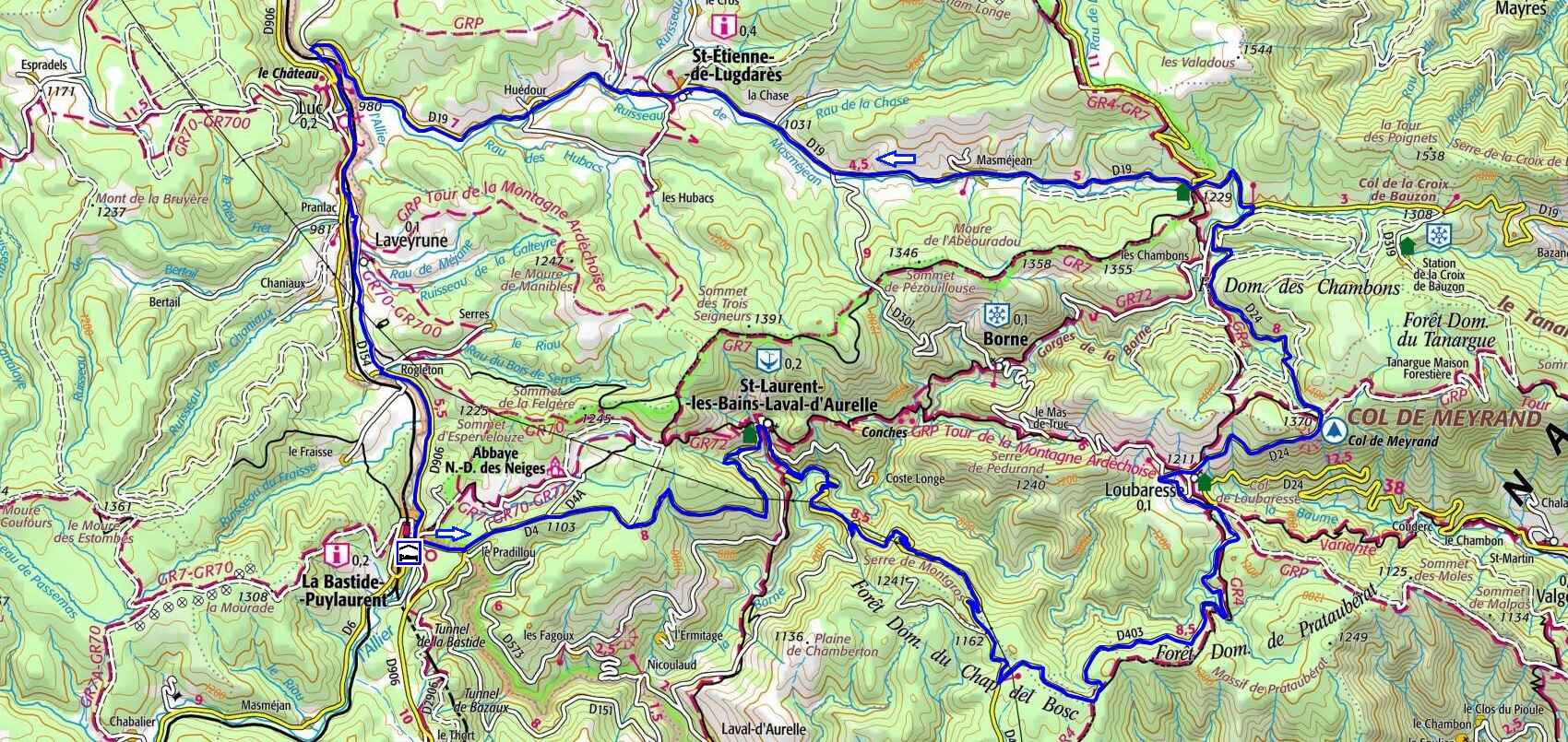
From L'Etoile, head toward the village center and continue straight in the direction of Villefort. Proceed to the Pradillou roundabout, then take the D4 straight ahead for 16.5 km. You will pass through Saint-Laurent-les-Bains and cross the Ceytrou bridge over the Borne River—an area featuring magnificent granite pools perfect for swimming—before reaching the Col du Chap del Bosc. At the pass, turn left onto the D403 and ride for 7.8 km toward Loubaresse, passing the Croix de la Femme Morte and the Bournet bridge. In Loubaresse, turn left onto the D24 and follow it for 9.3 km over the Col de Meyrand until you reach the D19. Turn left and stay on this road for 17.1 km, crossing the Col du Bez and passing through Masméjean, Saint-Étienne-de-Lugdarès, and Huédour, all the way to Luc and the D906. Upon reaching the D906, turn left toward La Bastide-Puylaurent and ride for 1.7 km. Next, take a sharp diagonal left onto the D76 to the Pranlac bridge, where you will cross into Ardèche. The road becomes the D154; follow it through Laveyrune until you reach Rogleton. Finally, turn left onto the D906 to return to La Bastide-Puylaurent.
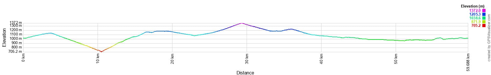
 Distance: 60 km. Maximum altitude: 1,363 m. Minimum altitude: 721 m. Total elevation gain: 1,273 m.
IGN Maps: Langogne (2737E). La Bastide-Puylaurent (2738E). Largentière, La Bastide-Puylaurent, Vivarais Cévenol (2838OT).
Print the route - Electric bike rental
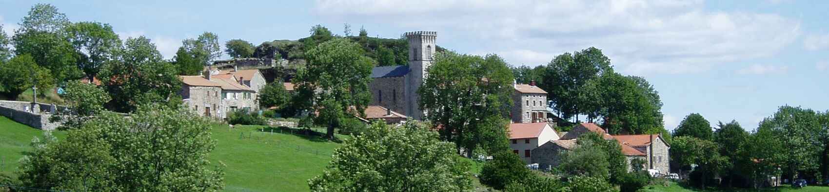
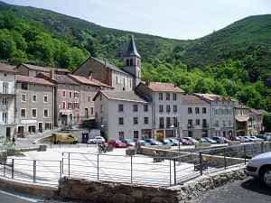
In this historic province, the landscape is divided between Haut-Vivarais in the north and Bas-Vivarais in the south. The Vivarais mountains stand like enduring stone sentinels along the eastern border of the Massif Central. Among them, the tower of Saint-Laurent-les-Bains proudly watches over the village from a rocky spur. Built in the 9th century, it has gracefully withstood the passage of time, with its six floors carefully preserved by the locals as a historical sanctuary. Perched high above the Borne valley, the village is crowned by the granite majesty of the Trois-Seigneurs peak. Its steep slopes tumble down more than a hundred meters to the rooftops, standing as a silent guardian over the valley's inhabitants. The fame of the Saint-Laurent-les-Bains thermal resort dates back to Roman times, long celebrated for the therapeutic virtues of its 53°C (127°F) waters. The Source de Saint-Laurent, emerging from the volcanic depths of the earth, has been praised for its healing benefits since the Middle Ages. Today, treatments such as weightless mud baths, thermal pool showers, poultices, and vaporarium sessions are offered within the intimate setting of three thermal establishments. Here, the healing waters flow through underground channels, providing comfort and relief to the many visitors who come seeking wellness each year.
Once, dominating the high mountains of these rugged regions, stood four imposing towers: those of Loubaresse, Borne, Saint-Laurent-les-Bains, and Luc. On dark nights, massive bonfires were lit atop these towers, acting as brilliant beacons that illuminated the countryside from afar. These fires served as vital signals during the disastrous and frequent feudal wars that pitted rival lords against one another. Of these four towers, one has sadly vanished. Located 1,242 meters above sea level on the filled-in crater of one of Vivarais' oldest extinct volcanoes, the Loubaresse tower created a striking, picturesque silhouette against the landscape and had long been respected by time. However, less than five years ago, a man with little regard for ancient ruins ordered it demolished and razed to the ground, repurposing the stones to rebuild the parish church of Loubaresse. The journey from Chambons to Loubaresse—a village historically populated almost exclusively by muleteers, robust and hardy mountain folk known more for their endurance than the graceful elegance of Andalusian muleteers—continues toward the Chat-del-Bos. From there, the road heads to Saint-Laurent-les-Bains, which lies just a league away. Along this stretch, every well-trodden path gradually fades into the wild. Before you lie only open meadows and sweeping fields, through which wandering beasts and adventurous travelers venture off into the unknown.
The Château de Luc traces its origins to an ancient Celtic site on the edge of the Mercoire forest, overlooking the mysterious Tanargue massif. Constructed between the 6th and 10th centuries, it dates back to a time when Gévaudan was an independent province divided into eight baronies. The castle belonged to the Lords of Luc, who were allied with the powerful Barons of Randon and, consequently, the illustrious House of Joyeuse. Known for their bravery, piety, and sense of justice, the Lords of Luc held the privilege of minting money, levying taxes, administering justice, and waging war. Though respected and feared by their vassals, they were also known for their generosity, providing refuge and aid to the needy, the sick, and weary pilgrims.