


La Garde-Guérin is a fortified village gracefully located in the Lozère department in the Occitanie region. Proudly perched on a rocky plateau in a beautiful setting, it is one of the many charming small villages to discover in the Cévennes National Park.
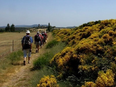
The historic village is traversed by the Chemin de Régordane (GR®700), a historic communication route connecting the Massif Central to the Mediterranean, which was highly frequented in the Middle Ages. Originally, this vital path was known as the Estrade (from Occitan estrada, "great road", derived from the Latin strata). In the 12th century, at the official request of the Bishop of Mende, the village became a strategic border post defended by a garrison responsible for the safety of travelers and goods on the Régordane. Throughout the 13th century, this place was simply called "La Garde".
The name "Guérin" only appeared in 1298. The fortified village, or historic castrum of La Garde, was jointly owned by a community of knight pariers (in Occitan: "les égaux", meaning "the equals", from Latin pares). This economic and military brotherhood, inspired by the flourishing chivalric schools in 12th-century France, swore allegiance to the Bishop of Mende. Each parier owned a parérie (a share of the route) for which he assumed responsibility and collected revenues: tolls, cartelage (grain measurement tax), guidance and protection of travelers, animals, and goods, as well as the unusual pulvérage (a tax on the dust raised by passing herds).
The village's population has varied greatly over the centuries. There were more than 100 inhabitants in 1789, 158 in 1846, and 84 in 1936. Today, about a dozen inhabitants live there year-round, though the population increases to around a hundred during the summer season.
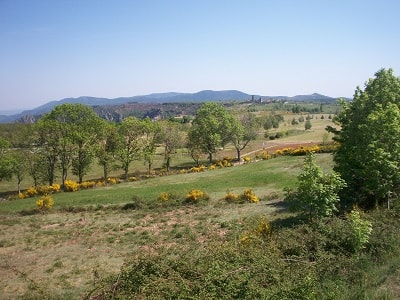
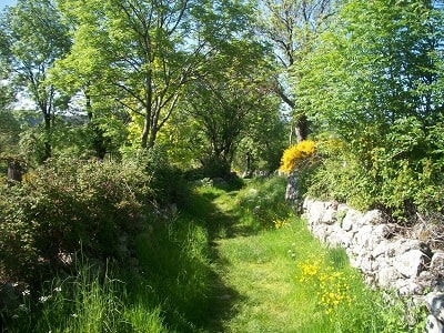
Located in the Cévennes National Park, a mountainous region in southern France, La Garde-Guérin benefits from an exceptional natural environment. The region is widely known for its spectacular landscapes, rivers, and deep gorges, as well as its incredibly rich and varied flora and fauna. Common plant species include holm oak, downy oak, chestnut, beech, Scots pine, and juniper, interspersed with aromatic plants and flowers such as thyme, lavender, heather, foxglove, martagon lily, and the delicate lady's slipper.
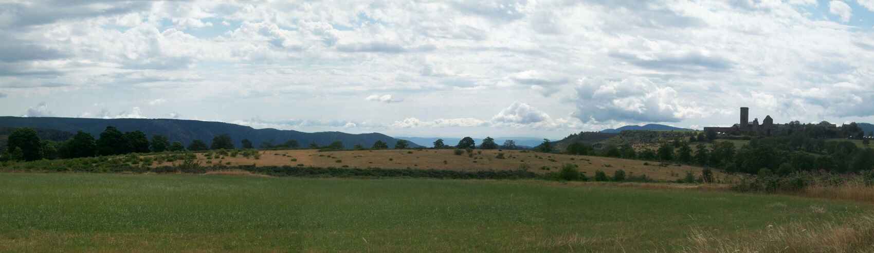
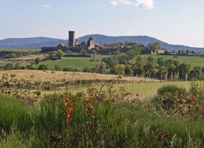
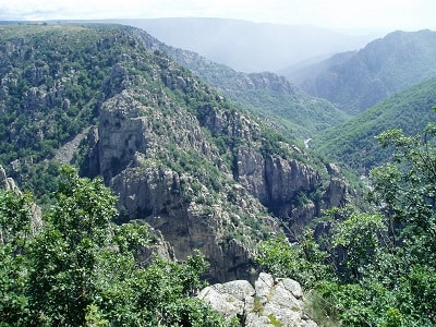
Isolated on its plateau, this fortified village majestically dominates the jagged rocks of the impressive Chassezac gorge. In the 12th century, the Bishop of Mende decided to fortify it to protect travelers using the GR®700 Régordane Way, then the main communication route between Auvergne and Roussillon. 27 nobles, the famous "pariers", settled there.
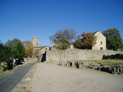
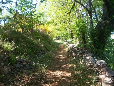
Their houses, all perfectly identical, still stand today. Closed to automobile traffic, the village has preserved its authentic medieval appearance almost intact, proudly displaying the remains of its castle and much of its original ramparts. Today, many of the old parier houses serve as sheepfolds for the few remaining inhabitants. One kilometer to the north, a path branching off from the old D906 road leads in five minutes to the dizzying Chassezac belvedere, overlooking the chaotic, deep gorges where the torrent roars below.
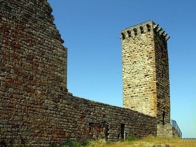
A renowned stopover on the GR®700 Régordane Way, La Garde-Guérin is now a highly attractive tourist site. On-site, the tall watchtower still stands, once surrounded by ramparts of which beautiful ruins can still be seen. The beautifully restored castle and village form a remarkably homogeneous medieval ensemble. It was once the exclusive domain of the "knight pariers," a unique military association acting as a police militia that protected and guided merchants. Up to thirty of them shared this duty, subject to meticulous statutes regulating charges and revenue distribution.
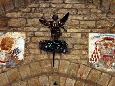
The massive donjon is 27 meters high, featuring barrel-vaulted floors. Originally lacking interior stairs, the levels communicated via ladders and narrow trapdoors. The village church, formerly the castle's private chapel, has been superbly restored and is considered a true jewel of Romanesque architecture. From the top of the triumphal arch, a polychrome statue of Saint Michael tramples a horned devil, watching over beautifully carved capitals. Many ancient stone houses in the village have also been carefully restored, revealing superb doorways and antique staircases.
In 1965, La Garde-Guérin was an almost abandoned village where a few farmers struggled to survive. However, it possessed a rich architectural heritage worth preserving. Recognizing the urgency to save and revitalize this unique site, the Paris Architecture Directorate selected it as a pilot village, granting significant subsidies for its rehabilitation.
Starting in 1966, an extensive project began: the creation of an inn in one of the village's most beautiful houses, the restoration of the classified historical church, the paving of streets, the consolidation of ramparts, and the installation of running water. Several years of work turned this bold gamble into a resounding success. 25 years later, the results were undeniable: the original inhabitants remained, while new residents settled permanently or for holidays, breathing new life into the previously abandoned houses.
Today, the concerted efforts of the inhabitants through a dedicated association ensure the continuity of this restoration. La Garde-Guérin has become a major heritage site admired by thousands of visitors each year. Strict respect for the environment and the demanding enhancement of its architectural heritage have restored the site's soul and vitality. It is a strong identity, rich in a carefully transmitted past, inviting visitors to realize the importance of their environment as a necessary component of their balance and way of life. The true art of living is found right here, in the raw beauty of these places!
La Garde-Guérin is an old fortified village remarkably situated alongside the GR®700 Régordane Way, majestically dominating the spectacular Chassezac Gorges from a height of 400 meters.
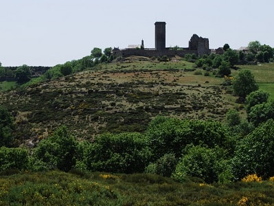
The traveler can see the village from afar, built at nearly 900 meters altitude on a sandstone plateau often swept by winds. The base of this plateau is formed of granite rocks through which the Chassezac torrent has carved a labyrinth of impressive faults. Thanks to this dominant position, the village enjoys an exceptional panoramic view of the surrounding landscape. One only needs to stroll to the Pré de la Tour or lean over the Chassezac belvedere to be convinced: the view remains completely unobstructed in all directions to this day. Furthermore, the site is crossed by the Régordane Way, which has always played a crucial historical role.
It is a natural communication route traced from north to south on the eastern slope of the Cévennes. This historic artery connected Montpellier and Nîmes to Le Puy-en-Velay (the starting point of the St. James' Way GR®65, the GR®700 Régordane or St. Gilles Way, and the GR®70 Stevenson Trail) and to Clermont-Ferrand. It passed through Alès, Portes, Chamborigaud, Génolhac (Tour of Mont Lozère GR®68), crossing Villefort, and continuing towards La Garde-Guérin, Prévenchères, Le Thort, La Bastide-Puylaurent, Luc, and Langogne.
The area bears traces of solid human settlement dating back to the Neolithic period. It is inevitable that the ancient Régordane path was lined with more or less fortified stations very early on. La Garde-Guérin's layout made it the ideal place to establish an "éperon barré", a defensive camp originally protected by wooden palisades rather than stone walls.
Later, the Gauls most likely erected an oppidum or stronghold here. Although remains from this period are scarce, it is certain that the Régordane was already used as a pre-Roman transhumance route.
Before Caesar's conquest of Gaul in 52 BC, the Celtic Gabales tribe occupied the territory of present-day Lozère. As clients of the powerful Arverni tribe, to whom they owed respect, loyalty, and military assistance, they actively fought alongside Vercingetorix for Gallic independence.
A cheese appreciated by the Romans
The Gabales lived mainly from agriculture and livestock. They used the original GR®700 route not only for transhumance but also as a trade route. Wine and other Cévennes specialties, such as their famous cheeses, were exported and sold as far south as Nîmes.
Pliny the Elder, the famous Roman naturalist who died in the 1st century AD during the eruption of Mount Vesuvius, stated that the most highly prized cheese in Rome came from Mont Lozère and the Cévennes. The Gallo-Romans continued to use this route. Far from always drawing straight lines, Roman roads often followed the winding paths of earlier Gallic routes. They traveled with carts, and a relay system along the road allowed Mediterranean goods to reach Lozère. Oyster shells have even been found during archaeological excavations here. In certain places, such as the Estrade of Saint-André-de-Capcèze, the deep ruts carved into the rock by cart wheels are still clearly visible, with a gauge of 1.42 meters—exactly the same as measured in Pompeii. In Coudoulous, on a branch road heading west towards Mende, one can even see notches carved into the stone to wedge the wheels' "shoes," allowing drivers to secure their heavy carts on steep climbs.
Near this stop, Latin inscriptions carved into the rock have been discovered: "Marcus" (a Roman first name) and "Jovi" (the god Jupiter), proving irrefutably that the Romans used this road. The Régordane likely remained in use during the Merovingian and Carolingian periods. Travelers used it at their own risk, as evidenced by Le Charroi de Nîmes, a famous chanson de geste recounting how Frankish troops descended this route to free Nîmes from the Saracens. However, after the collapse of the Carolingian Empire, the central power could no longer guarantee travelers' safety. As historian Georges Duby notes, south of the Loire, "past the early 10th century, the evolution of powers continued in independence."
A privileged site
In this context, local powers organized around certain geographically privileged sites. La Garde-Guérin, blocking a highly frequented communication axis, was naturally one of them. Aware of this strategic advantage, lords established a system for guarding, toll collection, and protecting travelers as early as the 11th century, or perhaps even earlier. A first castle with a watchtower was likely built very early on to monitor this open horizon, giving the settlement its original name: "La Garde".
In the Etymological Dictionary of Place Names in France, we learn that the word "Garde" comes from the Germanic Wart, meaning watchtower or fortress. It is a common place name in France (such as La Garde-Freinet or La Garde-Adhémar), invariably designating towns built on strategic heights. In La Garde-Freinet, for example, a Saracen fortress was built in the 9th century. A text written in late Latin in the 12th century mentions the "castrum quod vocatur la Garda" (the stronghold called La Garde). As for the addition of the name "Guérin", the exact date remains uncertain. It is generally assumed that the lords who settled there in the 12th century bore this name, which was very common in the baronies of Randon, Apcher, and Tournel. The existence of the Guérin lineage is attested as early as 1054 in a deed of donation to the abbey of Gellone (now Saint-Guilhem-le-Désert).
Ultimately, a member of the Guérin family from Tournel took control of this castle and became its suzerain. The Barony of Tournel, master of Mont Lozère and part of the Causse de Sauveterre, was already firmly established in Villefort. Aware of the importance of this neuralgic point, they focused their attention on securing the Régordane Way, then the sole penetration route connecting the South to the Massif Central, as the Rhône Valley was a strictly controlled border at the time. Adding "Guérin" to La Garde was an obvious tribute to the power of these Tournel lords. (Association G.A.R.D.E, La Garde-Guérin, 48800 Villefort)
The Secret of the Donjon of La Garde-Guérin
Once upon a time, in the heart of the 12th century, there was a small village perched on a rocky plateau, surrounded by thick forests and deep gorges. This village was La Garde-Guérin. Its stone houses lined the winding streets, and at the top of the hill proudly stood an imposing donjon. The 27-meter-high tower was the symbol of the Pariers knights' power, noblemen who had sworn to protect travelers using the Régordane Way. But behind its thick walls lay a mystery, a secret fiercely guarded by the village elders.
One winter evening, while snow covered the roofs, a curious young shepherd named Gaspard discovered a hidden trapdoor beneath an old tree stump. Intrigued, he descended into the dark depths of the donjon, guided by the flickering light of his torch.
There, in a forgotten vaulted room, he found a carved wooden chest. Inside lay a parchment yellowed by the centuries. Gaspard deciphered the ancient characters and discovered the true history of the village. He learned that the Parier knights were not only guardians of the road but also keepers of a legendary treasure. This hoard, hidden somewhere in the donjon's underground passages, consisted of precious artifacts, invaluable jewels, and above all, a mysterious flask containing an elixir capable of curing all diseases.
Gaspard decided to share his discovery with the villagers. Together, they braved the traps and riddles left by the ancient knights, exploring the donjon's secret passages. Although they found hidden rooms filled with incredible riches, the precious elixir remained undiscovered.
Over the years, the village prospered peacefully thanks to this newfound treasure. The inhabitants lived in harmony, healed of their ailments, and the legend of La Garde-Guérin spread throughout the region. One day, however, a stranger named Lorenzo arrived. With eyes burning with greed, he came solely to steal the elixir. He sneaked into the donjon, solved the riddles with diabolical skill, and finally reached the room where the famous flask rested.
But the moment he reached out to take it, a mysterious force violently threw him back against the cold stone, leaving him unconscious. When he awoke, Lorenzo's heart had changed. His greed had been replaced by genuine compassion for the villagers, and he decided to become the treasure's new protector instead. Since that day, it is whispered, La Garde-Guérin has remained a place of healing for all those seeking light, and the secret of the donjon remains well-guarded, faithfully passed down from generation to generation.