


Luc in Lozère


Luc, nestled in the high valley of the Allier, is a village with a discreet charm in the Occitanie region. Its landscape is characterized by the foothills of the Cévennes and the Margeride, offering untamed nature where mountain flora coexists with ancient forests. The wildlife is rich, notably featuring the passage of wolves and the presence of numerous birds of prey. The history of the place is dominated by the majestic ruins of its medieval castle, a testament to its past strategic importance. This historical heritage, built on a rocky outcrop, provides a spectacular view of the valley. The village itself retains beautiful granite houses, typical of local architecture. Part of the historic Gévaudan, its past is closely linked to the legends and significant events of this land.
 Luc (from lucus, meaning sacred wood) certainly has a very ancient origin. Its hospital and church, dating from the 12th or 13th century, constituted a priory that depended on the Aubrac domain. In the main street, at the corner of a house near the post office, a small statuette from the 14th century, known as the "Cagassou," depicts a man squatting in an unambiguous position.
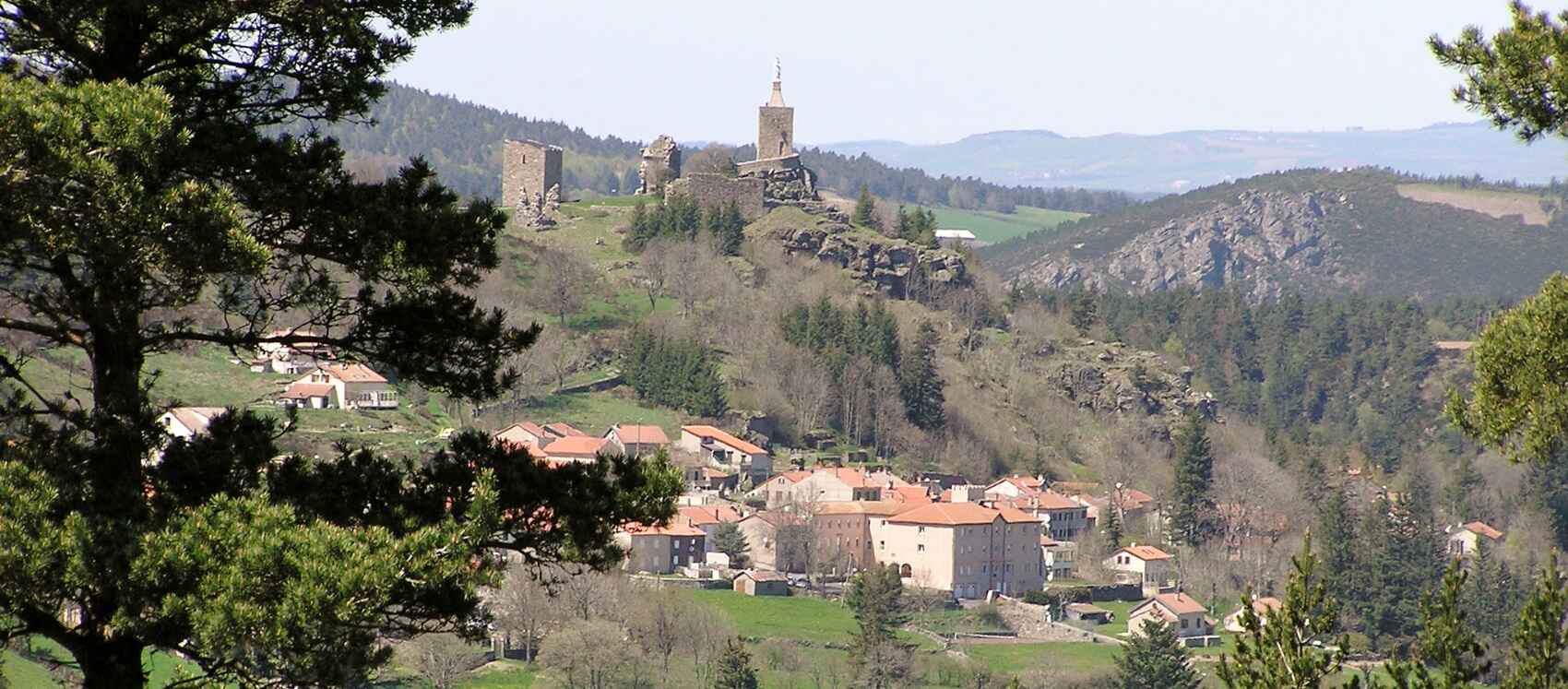
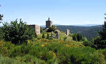
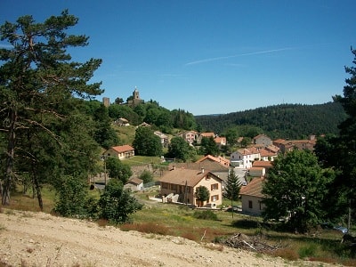
 From the castle that overlooks the village (featuring imposing ruins and herringbone walls from the 12th century), one can enjoy a sweeping panorama. A statue of the Virgin Mary was erected in 1878 on a restored tower. The choir of the church contains some remnants of the 13th-century building. Across the street stands the old building of the priory.
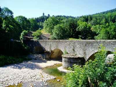
Between the Cévennes to the South and the Margeride to the North; facing the Tanargue to the East and the Mercoire forest to the West, the Allier River stretches at the foot of the village of Luc. The village likely owes its origin to the Mercoire forest, which extended throughout the region at the beginning of our era and was dedicated to the worship of the Roman god Mercury. Dominating the village, the ruins of the castle instantly draw the attention of passersby.
Built before the 12th century on a Celtic site, it was one of the most important strongholds in the region. Its architecture in "opus spicatum" (herringbone pattern) is remarkable. Enlarged over the years through strategic alliances, it has retained, despite its current degradation, the imposing characteristics of a military fortress. Guardian of the Chemin de la Régordane (a crucial link between the Midi and Auvergne, frequently traveled by pilgrims heading to Saint-Gilles), the Castle of Luc was a strategic point between the provinces of Gévaudan and Vivarais.
Until the 13th century, this path (the current street crossing the village) allowed for the development of many artisanal and commercial activities. The castle was then the seat of an important barony belonging to the De Luc family. Subsequently, due to various alliances, it became the domain of the most illustrious noble families of the region: d'Anduze, de Randon, de Polignac, de Muras, de Merle, and de Périer.
 The Hundred Years' War, followed by the Wars of Religion, did not spare the village: there was an attack on the castle by the English and brigands around 1380, and the looting of the presbytery at the end of the 17th century. These conflicts led the states of Gévaudan to install "a foot and horse garrison at the Castle of Luc." It seems to have been dismantled on the orders of Cardinal Richelieu around 1630.
The French Revolution, with the abolition of feudal rights, as well as the harshness of the climate and the challenges of time, brought the castle to its current state of degradation. However, two important events occurred in the 19th century.
 In 1878, the parishioners of Luc transformed the keep into a chapel and installed a statue of the Virgin Mary on its terrace. At the same time, a Scottish writer, Robert Louis Stevenson, accompanied by his donkey Modestine, undertook his famous Travels with a Donkey in the Cévennes. They passed by the castle and stopped in Luc on September 25, 1878. Coming from Langogne via Cheylard-l'Évêque, the Stevenson path (GR®70) runs along the Allier River towards the Abbey of Notre-Dame-des-Neiges (historical variant) and La Bastide-Puylaurent.
For a long time, the castle and its rich historical past were left unmentioned. But in 1978, a few friends decided to give it a renewed place in local life. They founded an association for the preservation and enhancement of the Castle of Luc. Its goal is to preserve and restore the remains, but also to deepen its history to make it accessible to a broader audience.
Since then, a joint effort by the municipality and the association has allowed several restoration campaigns to be undertaken. Soon, visitors will be able to climb to the top of the high tower, from where they can admire the entire chain of the Puys and the peaks of Vivarais and Velay.
In the 18th and 19th centuries, mule caravans regularly used the Régordane way and stopped in Luc. The same was true for transhumant herds: several thousand heads of livestock grazed the lands every year. It was the arrival of the railway that allowed Luc to become an important tourist station, especially appreciated by visitors from the south.
 Some architectural remnants still exist in the village.
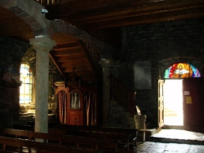
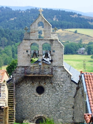
The calvary, built in 1904, and the Romanesque church, partly rebuilt in 1834 while retaining its core and its capitals from the 13th century. A porch opposite the church, topped with a Maltese cross (1825), and the facade of the old priory adjacent to the church (1776). A door lintel, facing the former weighbridge (former vicarage, 1871), and a sculpture from the 14th century affectionately called "Le Marmouset," near the post office.
 A stone cross topped with a coat of arms stands near the fountain in the middle of the village, and a vault key (bearing the coat of arms of an abbot of Chambons) can be seen near the old sawmill after the station. There are also the remains of an old mill attached under the dam below the station, some crosses serving as reminders of ecclesiastical missions from the beginning of the century, and a few statues from the former congregational schools that were previously installed in Luc.
The Régordane Way (currently the GR®700), an ancestral route, is considered the Cévennes section of the old road from Paris to lower Languedoc. It crossed the Central Massif through Clermont, Brioude, Le Puy-en-Velay, Pradelles, Lesperon, Luc, La Bastide-Puylaurent, Prévenchères, Villefort, Génolhac, Chamborigaud, Alès, Nîmes, and Saint-Gilles.
This name "Régordane" only applied to the portion between Alès and Luc. It witnessed thousands of transhumants, processions of Phoenicians, Greeks, Romans, warriors, and pilgrims who left from Orléans to reach the famous abbey of Saint-Gilles. It was traveled by merchants going from north to south to sell cloth and textiles from Flanders, or from south to north to transport products from the East, spices, and precious fabrics. In 1295, Genoese sailors enlisted by the King of France to invade England also marched along this very path.
"Régordane" was also the name of a family that, in the 12th, 13th, and 15th centuries, included several legal members in Montpellier and Alès. This royal road was eventually supplanted after the 15th century by the straighter road of the Rhône valley.
Association "Friends of the Castle of Luc".
Luc: A number of toponyms based on Latin names of plants belong to the Gallo-Roman period. This is the case with the Latin "Lucus" (meaning sacred wood, forest), which is the origin of many places named Luc, but also Lux (7 municipalities and place names) and Luz in Old French (21 municipalities and place names). Since a Celtic occupation is proven here, one might also think of the god Lug, or "Lugh" in Irish, identified with Mercury. (For context, Lyon comes from "Lugdunum," meaning the fortified city of Lug; the same etymology applies to the cities of Laon, Loudun, Loudon). See also "St-Étienne-de-Lugdarès".
Copyright©etoile.fr