


Short walks around Génolhac


 Path of Tretzedonis (The 3 Ladies)
Marking: Red
Departure: Parking lot of the Verfeuille jam factory
Distance: 1.95 km
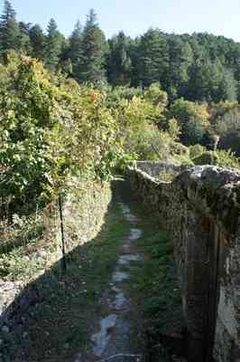
 From the parking lot, head toward the sheepfold and pass by it. Ignore the first path on the right and continue until you reach the fork (DFCI A99), then take the path on the right for 1 km. At the trail intersection, head up to the left until you reach the fork, and pass in front of the sheepfold again to return to the parking lot. Enjoy the very beautiful view of Mont Lozère and the Homol valley. To the east, you have a clear view of Amalet and Malons. Notice the "clèdes" (traditional small structures used for drying chestnuts). Also, note the dry stone walls delimiting the terraces (known as faïsses, bancels, or traversiers depending on the region), as well as the beautiful chestnut groves and numerous cherry trees. Before returning to the fork, you can climb to the "Ranc des Tretzedonis," an outcrop of schist and quartz offering a stunning circular panorama.
Path of the Vines
Marking: Red
Departure: Parking lot of the Verfeuille jam factory
Distance: 6 km
Difficulties: None, moderate elevation at the end of the route.
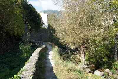
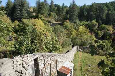
From the parking lot, walk toward the sheepfold and pass it. Ignore the first path on the right and continue to the fork (DFCI A99). Take the path on the left, walk 700 meters, and ignore the path on the right. At the intersection, turn right and continue for another 500 meters. At the pass, you will find a renewed chestnut grove. Take the path on the right and walk for 1 km. The path then becomes paved; continue for another kilometer until you reach road D134. Go up Avenue de la Régordane to the bridge over the railway, then turn right onto Avenue Gaston Deferre. Continue straight down the Grand-rue, passing in front of L'Arceau. Continue towards the town hall, cross the Gardonnette bridge, and turn right into Chareyral street, which climbs steeply to reach the Baurès road. Finally, turn right towards the industrial area to return to the parking lot.
After the fork, you'll be greeted by a beautiful view of the Amalet valley. At the next intersection, there is an underground DFCI tank used for fighting forest fires. A little further along, on the right, stands a charming "clède" previously used to dry chestnuts. At the pass, the owner has carefully renovated his chestnut grove by grafting and treating the trees. He cultivates the "M15" chestnut, a non-partitioned fruit. The path then opens onto the Homol valley, which springs from Mont Lozère and supplies fresh water to Génolhac. Along these sun-drenched slopes, there used to be vineyards and vibrant gardens, which have sadly disappeared today. Only a few small stone houses remain, once used to store the harvest and tools.
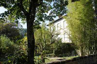
 Upon arriving at the departmental road, look to the left to see the beautiful Mas Chaptal, a former silk farm named after a famous painter. You then enter the medieval village with its typical Régordane architecture (a famous historical route running between Le Puy-en-Velay and Saint-Gilles). The Grand-rue boasts incredibly beautiful facades and a remarkable series of engraved stones. The bridge over the Gardonnette safely marks the limit of the medieval enclosure. The ascent of Chareyral offers a splendid view of the village, near the Huguenot graves located on a property below, as well as a magnificent panorama of Mont Lozère (1,400 m).
Path of Champrevart
Marking: Red
Departure: Old road from Concoules, 2nd bend
Distance: 2.2 km
Difficulties: None, accessible to strollers and bicycles.
 From the parking lot, take the path for 1.95 km. Rejoin the paved road and turn left to return to the parking lot. The route provides a very beautiful view to the south of the village and the Portes castle, then of Aujac to the east, and a stunning panorama to the northeast highlighting the Cham de Besse and Malons.
To the north, you can spot the Col de l'Ancise and Mont Lozère, followed by Monclar to the west. The path winds through beautiful chestnut trees and a lovely coniferous forest. Upon reaching the asphalt, you'll discover beautiful meadows where, hidden amid the gorse, lie the ruins of the house belonging to Nicolas Joany, a local tiler and prominent Camisard leader in 1702. There are several spots perfect for shaded picnics along the way.
Path of Plo des Egaux
Marking: Red
Departure: Col de Valoussière, intersection D998/D17
Distance: 1.5 km
Difficulties: None, accessible to strollers and bicycles.
Park on the trail at the start of the road leading to the stadium. Take the forest path for 1.5 km, cross the road leading to the stadium, turn left, and go 200 m to reach the parking lot. This trail runs along schistose terrain and offers a very beautiful view of the Luech valley to the south and the Homol valley to the east, as well as clear views of the Path of the Vines and Mont Lozère. The surrounding forest is composed of chestnut suckers (bouscasses), conifers, and sturdy holm oaks. Historically, the Plo des Egaux was a secret meeting place for Huguenot worship during the religious wars (known as the Desert). You'll find a nice spot for shaded picnics right at the entrance of the stadium.
By Philippe Pellecuier and Cyril Tillault.
Copyright©etoile.fr