
|
Round trip by bicycle in France through Lozere, Ardeche, Haute-Loire, Gard and the Cevennes National Park. |
|
|
Round trip by bicycle in France through Lozere, Ardeche, Haute-Loire, Gard and the Cevennes National Park. |
21,6km / 25km / 27,7km / 30km / 36km / 37km / 41,5km / 50km / 57,5km / 59,4km / 60km / 64,6km / 65km / 74km / 81km / 90km / 94,3km
Cycling Friends,
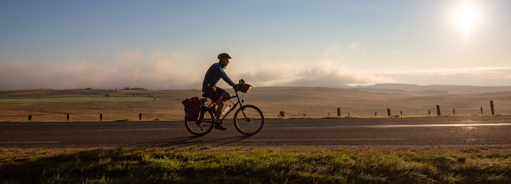
While staying at La Bastide-Puylaurent at L'Etoile, I just completed a 60 Km route concocted by Philippe. A perfect connoisseur of the region's topography, he was able to combine the tourist interest with all the magnificent landscapes and the sporting interest with a good dosage at the profile level with the route's layout. As far as I'm concerned, I completed this route alone with a road bike type race equipped with 2 plates of 50 and 38 teeth and a free wheel of 8 crowns of 14, 15, 16, 19, 21, 23, 26, 28 teeth. I am a 73-year-old Breton Cyclo who usually does an average of 2 weekly outings of 60 to 120 Km on routes that can sometimes be hilly at the terrain level but without common measure with most of the roads of the Ardeche and Lozere.
After the departure, towards Villefort, from La Bastide located at 1024 m, we climb slightly to the roundabout to continue in the direction of St Laurent les Bains. Quite quickly we approach the 8 Km descent to reach St Laurent les Bains at an Elevation of 840m. At the exit of the village, radical change of profile with a climb of 9 km at 10% average but with quite a few passages at least 12%. The landscape is very beautiful but the effort to climb is intense! Short of breath, probably amplified by the Elevation, and the legs a little hard, I had to abdicate 3 times to walk the steepest passages noting that my gear of 38x28 was insufficient and that a triple plate would have been welcome to reduce the effort. At these moments, humility is in order... but, of course, younger Cyclos well trained and with gears adapted to their possibilities can cross this pass of Chap del bosc located at 1169 m without having to put feet on the ground...
Past the pass, we catch our breath with the downhill or fairly flat part up to the village of Loubaresse from which we climb again but less long and with a lower percentage to reach the pass of Meyrand that we climb more easily. A stop just before the pass rewards you with a magnificent view.
It is then the part of the route back to La Bastide-Puylaurent much easier with the descent of the pass not very steep and the road that continues downhill to the village of Luc reached after crossing St Etienne de Lugdares. From Luc we head quietly towards La Bastide via the village of Laveyrune, the legs lighter and happy to have accomplished this route (at 19km/h average) which in its first part was not the easiest for me but it is such a pleasure to pedal in this beautiful region that the efforts are largely rewarded! It is really a route to do among the many others proposed by Philippe.
So don't hesitate to choose L'Etoile Guest House for the stage of your cyclo or pedestrian hiking circuit and also for a stay because you are perfectly welcomed, the guest table is excellent and Philippe will make you have a very good time.
***
Initially, it was about going up the Loire from Puy en Velay to Gerbier de Jonc, to join the Allier at its source and continue towards Langeac and Brioude before looping back to the Loire after Aurec.
Finally, we opted for the star-shaped route from L'Etoile to La Bastide-Puylaurent in Lozere. The bike is lighter and no anxiety about lodging at the end of the stage. The 5 days allowed us to dawdle in Ardeche, Haute-Loire and Lozere and above all, we did the descent of the Gorges de l'Allier; not by canoe but with a lot of climbs.
Loubaresse Loop (60km).
We leave La Bastide whistling and at the roundabout we continue towards St Laurent les Bains. After 3km of false flat climbing, we come out onto the Borne valley with the village of St Laurent below, which we reach in 3km of good descent. Stop in the square to visit the village and especially to dip your hands in the basin of the hot spring at 53°. The road continues to descend to Ceytrou (820m) to be done with caution as the hairpins are tight and the surface is bumpy. Laborious climb to the Col de Pra del Bosc (1170m). We take towards Loubaresse, a road in the forest that follows the contour line (+/- 1200m). Restoration at Loubaresse. We are at the foot of the Col de Meyrand which culminates at 1370m (you can also cut towards Borne and directly join St Etienne de Lugdares avoiding the pass), but the view from the orientation tables rewards the effort. The descent to the Chambons is on a very good road. At the crossroads, we turn left towards the Bez for a 1km climb before letting ourselves "roll" to Luc via St Etienne de Lugdares. At Pranlac, to avoid the main road, go through Laveyrune before joining La Bastide-Puylaurent again by the main road and arrive at L'Etoile to enjoy a beer on the terrace!
The Gorges de l'Allier (97km).
Departure from Langogne station towards Naussac, a concrete road and a steep climb take us over the top of the hill (Attention, start gently!). For the return you can go around Langogne and thus avoid this hard climb. Then, follow the lake of Naussac to the North towards Briges and Zabreges. At La Rouviere, we join the departmental road 988 at the roundabout, to continue towards Laval-Atger along the Chapeauroux. Before the bridge, turn right towards St Bonnet de Montauroux and Chapeauroux. We cross the Allier valley on the bridge that joins the Haute-Loire. At the Nouveau-Monde turn left towards St Haon (experienced cyclists: all the way to the left!). It's a 6km climb that presents itself to reach 1100m. At the top turn left towards the Souils, the Cros de St Haon and Alleyras (Romanesque church), the road overlooks the Allier with the Margeride on the horizon. At the Alleyras bridge, you have to go back up to St Didier d'Allier, then St Privat d'Allier afterwards you just have to let yourself descend to St Arcons d'Allier before taking the train at Langeac SNCF station to La Bastide-Puylaurent. Optionally, you can make the return by train from Pont d'Alleyras to Monistrol d'Allier (65km).
Tour of Moure de la Gardille (50km). We follow the Allier along the small road towards Chasserades (visit of the church and the village) then towards Mirandol and Les Chazeaux. Turn right towards Le Cheylard l’Eveque, 4km climb up to the Mercoire forest. The road passes a pass (1363m) not named, very beautiful road in the forest up to Le Cheylard l’Eveque. Severe climb of 1km, descent and climb back up to Espradels. Before Luc, we pass in front of the castle (mandatory visit), explanations on the panels. Cross the village and direction Laveyrune, Pranlac, Rogleton and La Bastide-Puylaurent.
The Espezonnette (60km). By train to Langogne. Leave it in the direction of Pradelles; 4km on the N88 before turning right towards Lesperon. Follow the Espezonnette up to Lanarce. 4km on the N102 to pass the Col de la Chavade. Turn right to swallow the Col du Pendu (1425m) and descend directly towards Le Bez (watch out for gravel). Turn right towards Luc and St Etienne de Lugdares then return to L’Etoile via Laveyrune and Rogleton. This circuit is accessible for a start despite the 4km on the N88 added to those on the N102. By Bernard and Margot Chatellard
Old romantic Hotel, L'Etoile Guest-House is a mountain retreat in the South of France. With a beautiful park along the Allier River, L'Etoile Guesthouse is located in La Bastide-Puylaurent between Lozere, Ardeche and Cevennes. Many hiking trails like GR®7, GR®70 Stevenson trail, GR®72, GR®700 Regordane way, Cevenol, GR®470 Allier river, Margeride. Many hiking loops. The right place to relax.
Copyright©etoile.fr